You are here: Home > Network List > TA - USArray Transportable Network (new EarthScope stations) Stations List
> Station E17A Martinsdale, MT, USA > Earthquake Result Viewer
E17A Martinsdale, MT, USA - Earthquake Result Viewer
| Earthquake location: |
North Of Svalbard |
| Earthquake latitude/longitude: |
80.3/-1.9 |
| Earthquake time(UTC): |
2009/03/06 (065) 10:50:29 GMT |
| Earthquake Depth: |
9.0 km |
| Earthquake Magnitude: |
6.6 MB, 6.5 MS, 6.5 MW, 6.4 MW |
| Earthquake Catalog/Contributor: |
WHDF/NEIC |
|
| Network: |
TA USArray Transportable Network (new EarthScope stations) |
| Station: |
E17A Martinsdale, MT, USA |
| Lat/Lon: |
46.46 N/110.86 W |
| Elevation: |
1835 m |
|
| Distance: |
47.6 deg |
| Az: |
297.767 deg |
| Baz: |
12.507 deg |
| Ray Param: |
0.06987787 |
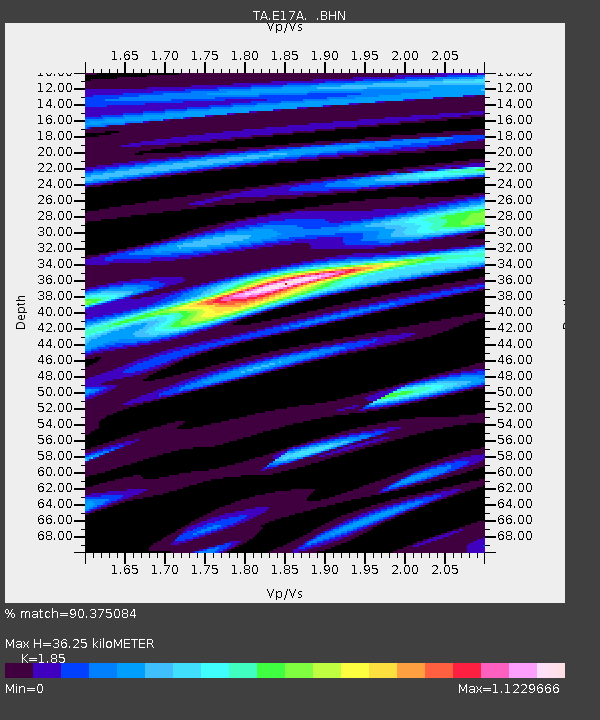
| Estimated Moho Depth: |
36.25 km |
| Estimated Crust Vp/Vs: |
1.85 |
| Assumed Crust Vp: |
6.306 km/s |
| Estimated Crust Vs: |
3.409 km/s |
| Estimated Crust Poisson's Ratio: |
0.29 |
|
| Radial Match: |
90.375084 % |
| Radial Bump: |
361 |
| Transverse Match: |
90.32542 % |
| Transverse Bump: |
400 |
| SOD ConfigId: |
2658 |
| Insert Time: |
2010-03-06 18:51:49.475 +0000 |
| GWidth: |
2.5 |
| Max Bumps: |
400 |
| Tol: |
0.001 |
|
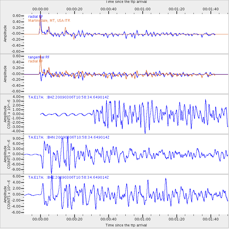
Signal To Noise
| Channel | StoN | STA | LTA |
| TA:E17A: :BHN:20090306T10:58:34.649014Z | 26.7688 | 4.36868E-6 | 1.6320044E-7 |
| TA:E17A: :BHE:20090306T10:58:34.649014Z | 10.46487 | 2.256504E-6 | 2.1562659E-7 |
| TA:E17A: :BHZ:20090306T10:58:34.649014Z | 4.8102365 | 8.998369E-7 | 1.8706707E-7 |
| Arrivals |
| Ps | 5.2 SECOND |
| PpPs | 15 SECOND |
| PsPs/PpSs | 21 SECOND |


