You are here: Home > Network List > TA - USArray Transportable Network (new EarthScope stations) Stations List
> Station I17K Unalakleet, AK, USA > Earthquake Result Viewer
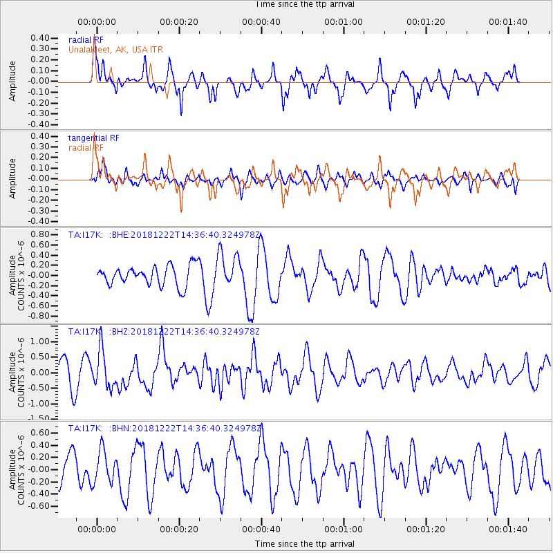
I17K Unalakleet, AK, USA - Earthquake Result Viewer
*The percent match for this event was below the threshold and hence no stack was calculated.
| Earthquake location: |
Vanuatu Islands |
| Earthquake latitude/longitude: |
-13.4/166.7 |
| Earthquake time(UTC): |
2018/12/22 (356) 14:25:02 GMT |
| Earthquake Depth: |
48 km |
| Earthquake Magnitude: |
6.0 Mww |
| Earthquake Catalog/Contributor: |
NEIC PDE/us |
|
| Network: |
TA USArray Transportable Network (new EarthScope stations) |
| Station: |
I17K Unalakleet, AK, USA |
| Lat/Lon: |
63.89 N/160.70 W |
| Elevation: |
105 m |
|
| Distance: |
81.0 deg |
| Az: |
13.974 deg |
| Baz: |
212.069 deg |
| Ray Param: |
$rayparam |
*The percent match for this event was below the threshold and hence was not used in the summary stack. |
|
| Radial Match: |
72.68667 % |
| Radial Bump: |
400 |
| Transverse Match: |
67.03767 % |
| Transverse Bump: |
400 |
| SOD ConfigId: |
13570011 |
| Insert Time: |
2019-05-02 03:40:34.186 +0000 |
| GWidth: |
2.5 |
| Max Bumps: |
400 |
| Tol: |
0.001 |
|
Signal To Noise
| Channel | StoN | STA | LTA |
| TA:I17K: :BHZ:20181222T14:36:40.324978Z | 1.6512913 | 6.2717123E-7 | 3.7980652E-7 |
| TA:I17K: :BHN:20181222T14:36:40.324978Z | 1.0024611 | 2.6040797E-7 | 2.5976868E-7 |
| TA:I17K: :BHE:20181222T14:36:40.324978Z | 1.6029786 | 3.175426E-7 | 1.9809535E-7 |
| Arrivals |
| Ps | |
| PpPs | |
| PsPs/PpSs | |


