You are here: Home > Network List > IU - Global Seismograph Network (GSN - IRIS/USGS) Stations List
> Station AFI Afiamalu, Samoa > Earthquake Result Viewer
AFI Afiamalu, Samoa - Earthquake Result Viewer
| Earthquake location: |
New Ireland Region, P.N.G. |
| Earthquake latitude/longitude: |
-3.7/152.8 |
| Earthquake time(UTC): |
2016/08/31 (244) 03:11:36 GMT |
| Earthquake Depth: |
499 km |
| Earthquake Magnitude: |
6.7 MO |
| Earthquake Catalog/Contributor: |
NEIC PDE/NEIC ALERT |
|
| Network: |
IU Global Seismograph Network (GSN - IRIS/USGS) |
| Station: |
AFI Afiamalu, Samoa |
| Lat/Lon: |
13.91 S/171.78 W |
| Elevation: |
706 m |
|
| Distance: |
36.4 deg |
| Az: |
108.446 deg |
| Baz: |
282.863 deg |
| Ray Param: |
0.074345075 |
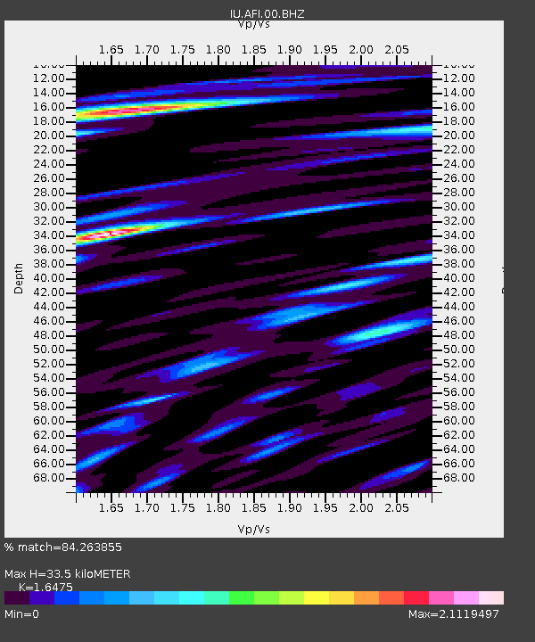
| Estimated Moho Depth: |
33.5 km |
| Estimated Crust Vp/Vs: |
1.65 |
| Assumed Crust Vp: |
4.24 km/s |
| Estimated Crust Vs: |
2.574 km/s |
| Estimated Crust Poisson's Ratio: |
0.21 |
|
| Radial Match: |
84.263855 % |
| Radial Bump: |
400 |
| Transverse Match: |
60.915844 % |
| Transverse Bump: |
400 |
| SOD ConfigId: |
1634031 |
| Insert Time: |
2016-09-14 03:12:46.687 +0000 |
| GWidth: |
2.5 |
| Max Bumps: |
400 |
| Tol: |
0.001 |
|

Signal To Noise
| Channel | StoN | STA | LTA |
| IU:AFI:00:BHZ:20160831T03:17:27.019012Z | 8.056316 | 6.367661E-6 | 7.9039364E-7 |
| IU:AFI:00:BH1:20160831T03:17:27.019012Z | 3.2455184 | 1.8761051E-6 | 5.780602E-7 |
| IU:AFI:00:BH2:20160831T03:17:27.019012Z | 6.5605574 | 4.769088E-6 | 7.2693337E-7 |
| Arrivals |
| Ps | 5.3 SECOND |
| PpPs | 20 SECOND |
| PsPs/PpSs | 26 SECOND |


