You are here: Home > Network List > TA - USArray Transportable Network (new EarthScope stations) Stations List
> Station J20K Nowitna River, AK, USA > Earthquake Result Viewer
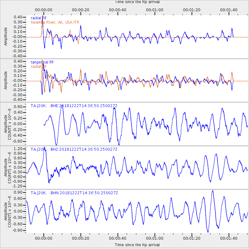
J20K Nowitna River, AK, USA - Earthquake Result Viewer
*The percent match for this event was below the threshold and hence no stack was calculated.
| Earthquake location: |
Vanuatu Islands |
| Earthquake latitude/longitude: |
-13.4/166.7 |
| Earthquake time(UTC): |
2018/12/22 (356) 14:25:02 GMT |
| Earthquake Depth: |
48 km |
| Earthquake Magnitude: |
6.0 Mww |
| Earthquake Catalog/Contributor: |
NEIC PDE/us |
|
| Network: |
TA USArray Transportable Network (new EarthScope stations) |
| Station: |
J20K Nowitna River, AK, USA |
| Lat/Lon: |
64.18 N/154.15 W |
| Elevation: |
314 m |
|
| Distance: |
82.9 deg |
| Az: |
16.184 deg |
| Baz: |
218.258 deg |
| Ray Param: |
$rayparam |
*The percent match for this event was below the threshold and hence was not used in the summary stack. |
|
| Radial Match: |
55.90996 % |
| Radial Bump: |
400 |
| Transverse Match: |
59.46018 % |
| Transverse Bump: |
370 |
| SOD ConfigId: |
13570011 |
| Insert Time: |
2019-05-02 03:40:38.147 +0000 |
| GWidth: |
2.5 |
| Max Bumps: |
400 |
| Tol: |
0.001 |
|
Signal To Noise
| Channel | StoN | STA | LTA |
| TA:J20K: :BHZ:20181222T14:36:50.250027Z | 2.2833014 | 7.626976E-7 | 3.3403282E-7 |
| TA:J20K: :BHN:20181222T14:36:50.250027Z | 1.1498343 | 3.4148312E-7 | 2.969846E-7 |
| TA:J20K: :BHE:20181222T14:36:50.250027Z | 0.8147737 | 2.5338903E-7 | 3.1099316E-7 |
| Arrivals |
| Ps | |
| PpPs | |
| PsPs/PpSs | |


