You are here: Home > Network List > TS - TERRAscope (Southern California Seismic Network) Stations List
> Station BAR Barrett Dam, California, USA > Earthquake Result Viewer
BAR Barrett Dam, California, USA - Earthquake Result Viewer
*The percent match for this event was below the threshold and hence no stack was calculated.
| Earthquake location: |
Pacific-Antarctic Ridge |
| Earthquake latitude/longitude: |
-56.1/-142.6 |
| Earthquake time(UTC): |
1994/11/16 (320) 06:54:02 GMT |
| Earthquake Depth: |
10 km |
| Earthquake Magnitude: |
5.2 MB, 5.6 MS |
| Earthquake Catalog/Contributor: |
WHDF/NEIC |
|
| Network: |
TS TERRAscope (Southern California Seismic Network) |
| Station: |
BAR Barrett Dam, California, USA |
| Lat/Lon: |
32.68 N/116.67 W |
| Elevation: |
548 m |
|
| Distance: |
91.1 deg |
| Az: |
21.68 deg |
| Baz: |
194.214 deg |
| Ray Param: |
$rayparam |
*The percent match for this event was below the threshold and hence was not used in the summary stack. |
|
| Radial Match: |
68.07669 % |
| Radial Bump: |
400 |
| Transverse Match: |
56.438255 % |
| Transverse Bump: |
400 |
| SOD ConfigId: |
4480 |
| Insert Time: |
2010-02-26 14:02:20.996 +0000 |
| GWidth: |
2.5 |
| Max Bumps: |
400 |
| Tol: |
0.001 |
|
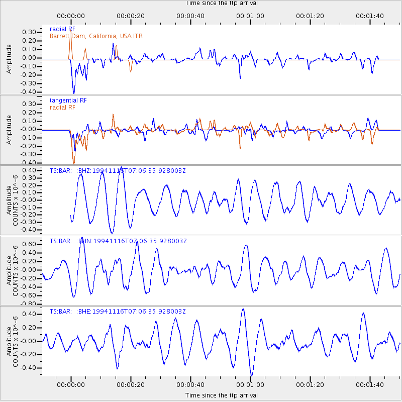
Signal To Noise
| Channel | StoN | STA | LTA |
| TS:BAR: :BHN:19941116T07:06:35.928003Z | 1.6372008 | 4.9431645E-7 | 3.019278E-7 |
| TS:BAR: :BHE:19941116T07:06:35.928003Z | 0.83383554 | 7.462927E-8 | 8.9501185E-8 |
| TS:BAR: :BHZ:19941116T07:06:35.928003Z | 0.51098055 | 1.2955034E-7 | 2.5353285E-7 |
| Arrivals |
| Ps | |
| PpPs | |
| PsPs/PpSs | |


