You are here: Home > Network List > TA - USArray Transportable Network (new EarthScope stations) Stations List
> Station E17A Martinsdale, MT, USA > Earthquake Result Viewer
E17A Martinsdale, MT, USA - Earthquake Result Viewer
| Earthquake location: |
Southern Greece |
| Earthquake latitude/longitude: |
38.0/21.5 |
| Earthquake time(UTC): |
2008/06/08 (160) 12:25:29 GMT |
| Earthquake Depth: |
16 km |
| Earthquake Magnitude: |
6.2 MB, 6.3 MS, 6.3 MW, 6.3 MW |
| Earthquake Catalog/Contributor: |
WHDF/NEIC |
|
| Network: |
TA USArray Transportable Network (new EarthScope stations) |
| Station: |
E17A Martinsdale, MT, USA |
| Lat/Lon: |
46.46 N/110.86 W |
| Elevation: |
1835 m |
|
| Distance: |
85.7 deg |
| Az: |
329.201 deg |
| Baz: |
35.836 deg |
| Ray Param: |
0.044540238 |
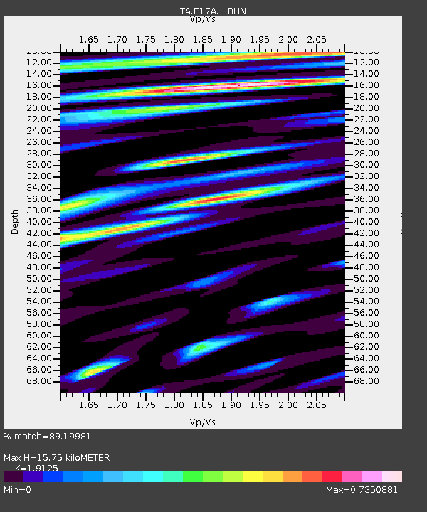
| Estimated Moho Depth: |
15.75 km |
| Estimated Crust Vp/Vs: |
1.91 |
| Assumed Crust Vp: |
6.306 km/s |
| Estimated Crust Vs: |
3.297 km/s |
| Estimated Crust Poisson's Ratio: |
0.31 |
|
| Radial Match: |
89.19981 % |
| Radial Bump: |
400 |
| Transverse Match: |
90.253204 % |
| Transverse Bump: |
400 |
| SOD ConfigId: |
2504 |
| Insert Time: |
2010-03-06 18:52:35.724 +0000 |
| GWidth: |
2.5 |
| Max Bumps: |
400 |
| Tol: |
0.001 |
|
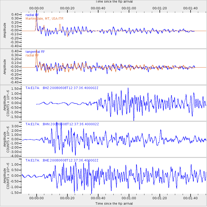
Signal To Noise
| Channel | StoN | STA | LTA |
| TA:E17A: :BHN:20080608T12:37:36.400002Z | 3.1480162 | 2.213764E-7 | 7.032251E-8 |
| TA:E17A: :BHE:20080608T12:37:36.400002Z | 0.90264994 | 6.926684E-8 | 7.673721E-8 |
| TA:E17A: :BHZ:20080608T12:37:36.400002Z | 1.202826 | 8.768627E-8 | 7.290021E-8 |
| Arrivals |
| Ps | 2.3 SECOND |
| PpPs | 7.1 SECOND |
| PsPs/PpSs | 9.4 SECOND |


