You are here: Home > Network List > TA - USArray Transportable Network (new EarthScope stations) Stations List
> Station E17A Martinsdale, MT, USA > Earthquake Result Viewer
E17A Martinsdale, MT, USA - Earthquake Result Viewer
| Earthquake location: |
Tonga Islands |
| Earthquake latitude/longitude: |
-20.8/-173.3 |
| Earthquake time(UTC): |
2008/06/26 (178) 21:19:15 GMT |
| Earthquake Depth: |
38 km |
| Earthquake Magnitude: |
6.0 MB, 5.8 MS, 6.2 MW, 6.1 MW |
| Earthquake Catalog/Contributor: |
WHDF/NEIC |
|
| Network: |
TA USArray Transportable Network (new EarthScope stations) |
| Station: |
E17A Martinsdale, MT, USA |
| Lat/Lon: |
46.46 N/110.86 W |
| Elevation: |
1835 m |
|
| Distance: |
87.5 deg |
| Az: |
37.855 deg |
| Baz: |
236.177 deg |
| Ray Param: |
0.043251254 |
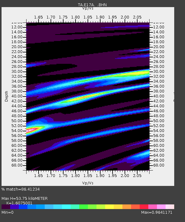
| Estimated Moho Depth: |
53.75 km |
| Estimated Crust Vp/Vs: |
1.61 |
| Assumed Crust Vp: |
6.306 km/s |
| Estimated Crust Vs: |
3.923 km/s |
| Estimated Crust Poisson's Ratio: |
0.18 |
|
| Radial Match: |
86.41234 % |
| Radial Bump: |
196 |
| Transverse Match: |
75.01759 % |
| Transverse Bump: |
400 |
| SOD ConfigId: |
2504 |
| Insert Time: |
2010-03-06 18:52:38.611 +0000 |
| GWidth: |
2.5 |
| Max Bumps: |
400 |
| Tol: |
0.001 |
|
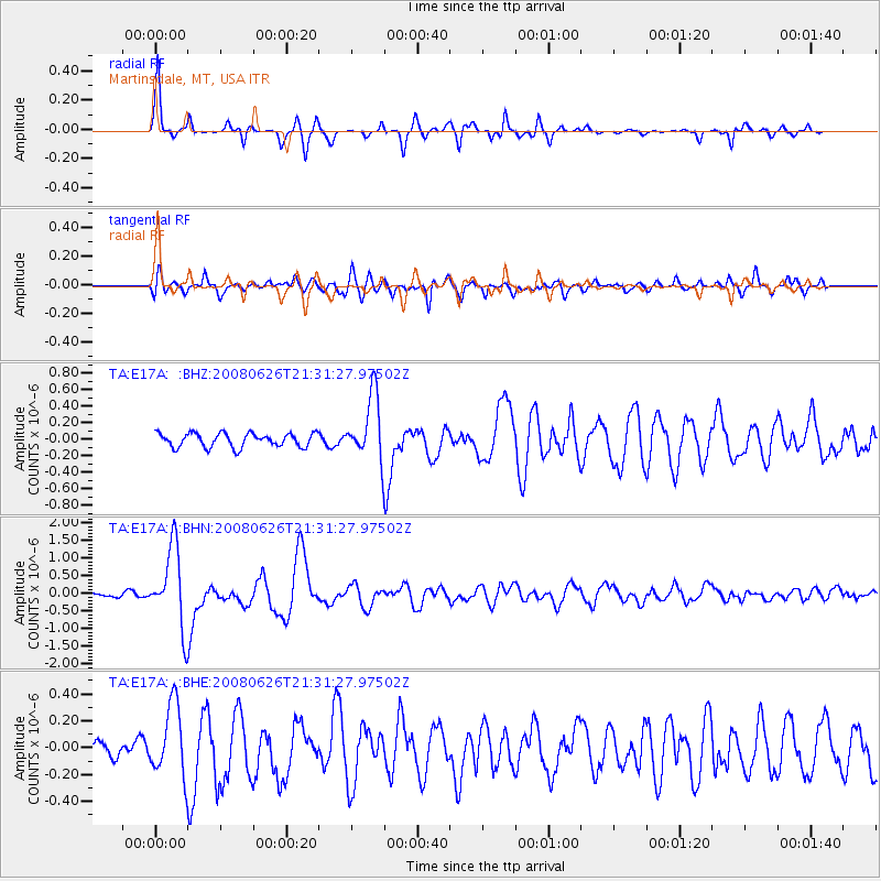
Signal To Noise
| Channel | StoN | STA | LTA |
| TA:E17A: :BHN:20080626T21:31:27.97502Z | 8.934532 | 1.1208724E-6 | 1.2545395E-7 |
| TA:E17A: :BHE:20080626T21:31:27.97502Z | 2.4636168 | 2.644127E-7 | 1.0732705E-7 |
| TA:E17A: :BHZ:20080626T21:31:27.97502Z | 4.64255 | 3.8864607E-7 | 8.371392E-8 |
| Arrivals |
| Ps | 5.3 SECOND |
| PpPs | 22 SECOND |
| PsPs/PpSs | 27 SECOND |


