You are here: Home > Network List > TS - TERRAscope (Southern California Seismic Network) Stations List
> Station BAR Barrett Dam, California, USA > Earthquake Result Viewer
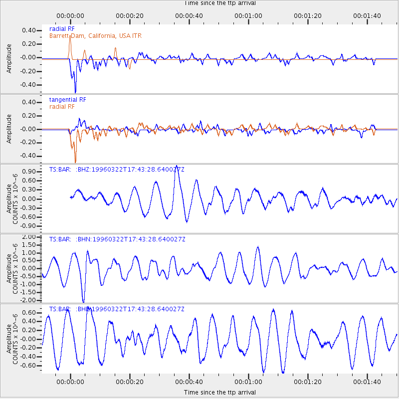
BAR Barrett Dam, California, USA - Earthquake Result Viewer
*The percent match for this event was below the threshold and hence no stack was calculated.
| Earthquake location: |
East Of North Island, N.Z. |
| Earthquake latitude/longitude: |
-35.2/-179.2 |
| Earthquake time(UTC): |
1996/03/22 (082) 17:31:06 GMT |
| Earthquake Depth: |
33 km |
| Earthquake Magnitude: |
5.6 MB, 5.7 MS, 6.0 UNKNOWN, 5.7 MS |
| Earthquake Catalog/Contributor: |
WHDF/NEIC |
|
| Network: |
TS TERRAscope (Southern California Seismic Network) |
| Station: |
BAR Barrett Dam, California, USA |
| Lat/Lon: |
32.68 N/116.67 W |
| Elevation: |
548 m |
|
| Distance: |
89.4 deg |
| Az: |
48.448 deg |
| Baz: |
226.582 deg |
| Ray Param: |
$rayparam |
*The percent match for this event was below the threshold and hence was not used in the summary stack. |
|
| Radial Match: |
71.34845 % |
| Radial Bump: |
400 |
| Transverse Match: |
69.10965 % |
| Transverse Bump: |
400 |
| SOD ConfigId: |
4480 |
| Insert Time: |
2010-02-26 14:02:23.597 +0000 |
| GWidth: |
2.5 |
| Max Bumps: |
400 |
| Tol: |
0.001 |
|
Signal To Noise
| Channel | StoN | STA | LTA |
| TS:BAR: :BHN:19960322T17:43:28.640027Z | 4.1620793 | 1.0192972E-6 | 2.4490095E-7 |
| TS:BAR: :BHE:19960322T17:43:28.640027Z | 1.602502 | 4.5217507E-7 | 2.821682E-7 |
| TS:BAR: :BHZ:19960322T17:43:28.640027Z | 2.1492908 | 4.4381952E-7 | 2.064958E-7 |
| Arrivals |
| Ps | |
| PpPs | |
| PsPs/PpSs | |


