You are here: Home > Network List > AV - Alaska Volcano Observatory Stations List
> Station SPCR Ckakachatna River, Mount Spurr, Alaska > Earthquake Result Viewer
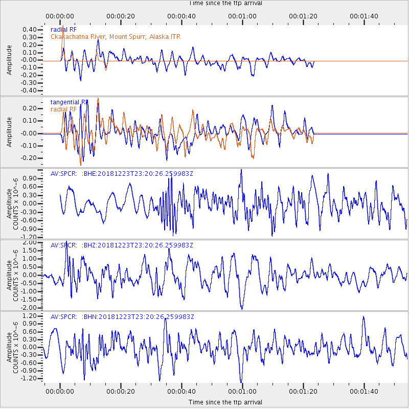
SPCR Ckakachatna River, Mount Spurr, Alaska - Earthquake Result Viewer
*The percent match for this event was below the threshold and hence no stack was calculated.
| Earthquake location: |
Tonga Islands |
| Earthquake latitude/longitude: |
-20.4/-175.1 |
| Earthquake time(UTC): |
2018/12/23 (357) 23:08:40 GMT |
| Earthquake Depth: |
100 km |
| Earthquake Magnitude: |
6.4 mww |
| Earthquake Catalog/Contributor: |
NEIC PDE/us |
|
| Network: |
AV Alaska Volcano Observatory |
| Station: |
SPCR Ckakachatna River, Mount Spurr, Alaska |
| Lat/Lon: |
61.20 N/152.21 W |
| Elevation: |
984 m |
|
| Distance: |
83.4 deg |
| Az: |
10.928 deg |
| Baz: |
201.549 deg |
| Ray Param: |
$rayparam |
*The percent match for this event was below the threshold and hence was not used in the summary stack. |
|
| Radial Match: |
55.146473 % |
| Radial Bump: |
400 |
| Transverse Match: |
62.719517 % |
| Transverse Bump: |
400 |
| SOD ConfigId: |
13570011 |
| Insert Time: |
2019-05-02 03:50:02.393 +0000 |
| GWidth: |
2.5 |
| Max Bumps: |
400 |
| Tol: |
0.001 |
|
Signal To Noise
| Channel | StoN | STA | LTA |
| AV:SPCR: :BHZ:20181223T23:20:26.259983Z | 4.487642 | 8.056846E-7 | 1.7953407E-7 |
| AV:SPCR: :BHN:20181223T23:20:26.259983Z | 1.3520113 | 4.5936594E-7 | 3.3976485E-7 |
| AV:SPCR: :BHE:20181223T23:20:26.259983Z | 0.90207994 | 3.0245963E-7 | 3.352914E-7 |
| Arrivals |
| Ps | |
| PpPs | |
| PsPs/PpSs | |


