You are here: Home > Network List > TA - USArray Transportable Network (new EarthScope stations) Stations List
> Station E17A Martinsdale, MT, USA > Earthquake Result Viewer
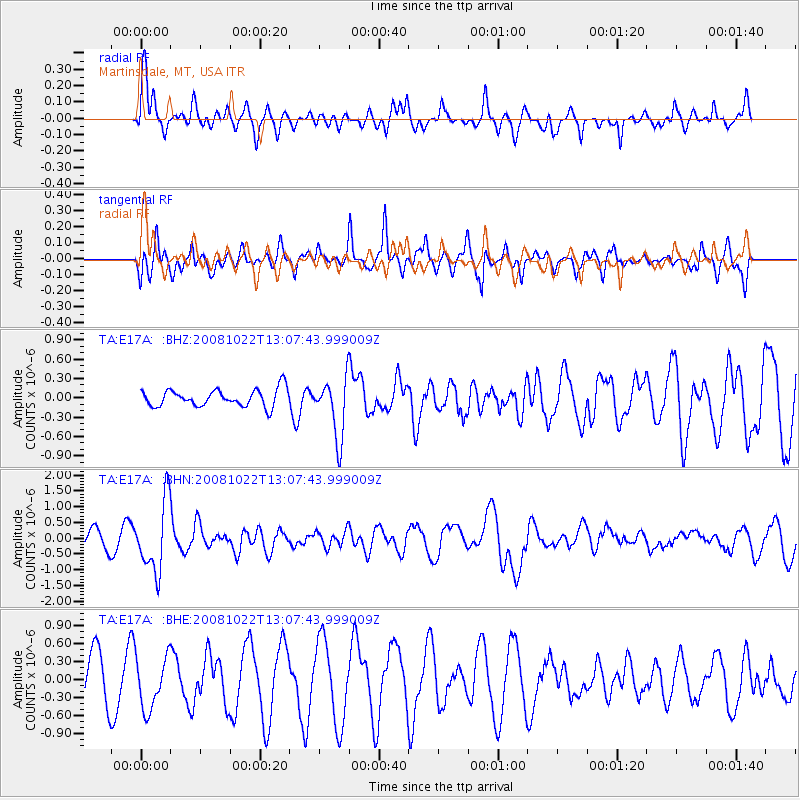
E17A Martinsdale, MT, USA - Earthquake Result Viewer
*The percent match for this event was below the threshold and hence no stack was calculated.
| Earthquake location: |
Tonga Islands |
| Earthquake latitude/longitude: |
-18.4/-175.4 |
| Earthquake time(UTC): |
2008/10/22 (296) 12:55:57 GMT |
| Earthquake Depth: |
233 km |
| Earthquake Magnitude: |
5.9 MB, 6.4 MW, 6.3 MW |
| Earthquake Catalog/Contributor: |
WHDF/NEIC |
|
| Network: |
TA USArray Transportable Network (new EarthScope stations) |
| Station: |
E17A Martinsdale, MT, USA |
| Lat/Lon: |
46.46 N/110.86 W |
| Elevation: |
1835 m |
|
| Distance: |
86.8 deg |
| Az: |
38.672 deg |
| Baz: |
239.118 deg |
| Ray Param: |
$rayparam |
*The percent match for this event was below the threshold and hence was not used in the summary stack. |
|
| Radial Match: |
48.336582 % |
| Radial Bump: |
400 |
| Transverse Match: |
61.368465 % |
| Transverse Bump: |
372 |
| SOD ConfigId: |
2556 |
| Insert Time: |
2010-03-06 18:53:14.824 +0000 |
| GWidth: |
2.5 |
| Max Bumps: |
400 |
| Tol: |
0.001 |
|
Signal To Noise
| Channel | StoN | STA | LTA |
| TA:E17A: :BHN:20081022T13:07:43.999009Z | 4.012575 | 1.1120858E-6 | 2.7715012E-7 |
| TA:E17A: :BHE:20081022T13:07:43.999009Z | 1.1285628 | 4.3157422E-7 | 3.8241046E-7 |
| TA:E17A: :BHZ:20081022T13:07:43.999009Z | 3.4741795 | 4.6316958E-7 | 1.333177E-7 |
| Arrivals |
| Ps | |
| PpPs | |
| PsPs/PpSs | |


