You are here: Home > Network List > TA - USArray Transportable Network (new EarthScope stations) Stations List
> Station E17A Martinsdale, MT, USA > Earthquake Result Viewer
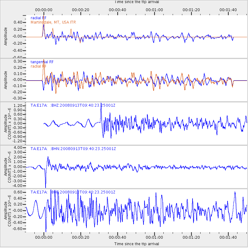
E17A Martinsdale, MT, USA - Earthquake Result Viewer
*The percent match for this event was below the threshold and hence no stack was calculated.
| Earthquake location: |
Colombia |
| Earthquake latitude/longitude: |
4.8/-75.5 |
| Earthquake time(UTC): |
2008/09/13 (257) 09:32:01 GMT |
| Earthquake Depth: |
133 km |
| Earthquake Magnitude: |
5.9 MB, 5.7 MW, 5.7 MW |
| Earthquake Catalog/Contributor: |
WHDF/NEIC |
|
| Network: |
TA USArray Transportable Network (new EarthScope stations) |
| Station: |
E17A Martinsdale, MT, USA |
| Lat/Lon: |
46.46 N/110.86 W |
| Elevation: |
1835 m |
|
| Distance: |
51.5 deg |
| Az: |
329.297 deg |
| Baz: |
132.601 deg |
| Ray Param: |
$rayparam |
*The percent match for this event was below the threshold and hence was not used in the summary stack. |
|
| Radial Match: |
71.058304 % |
| Radial Bump: |
400 |
| Transverse Match: |
64.658356 % |
| Transverse Bump: |
400 |
| SOD ConfigId: |
2560 |
| Insert Time: |
2010-03-06 18:53:18.386 +0000 |
| GWidth: |
2.5 |
| Max Bumps: |
400 |
| Tol: |
0.001 |
|
Signal To Noise
| Channel | StoN | STA | LTA |
| TA:E17A: :BHN:20080913T09:40:23.25001Z | 13.845173 | 1.2756861E-6 | 9.2139416E-8 |
| TA:E17A: :BHE:20080913T09:40:23.25001Z | 2.259504 | 2.886918E-7 | 1.2776778E-7 |
| TA:E17A: :BHZ:20080913T09:40:23.25001Z | 3.9888058 | 4.7833703E-7 | 1.1991986E-7 |
| Arrivals |
| Ps | |
| PpPs | |
| PsPs/PpSs | |


