You are here: Home > Network List > US - United States National Seismic Network Stations List
> Station HAWA Hanford, Washington, USA > Earthquake Result Viewer
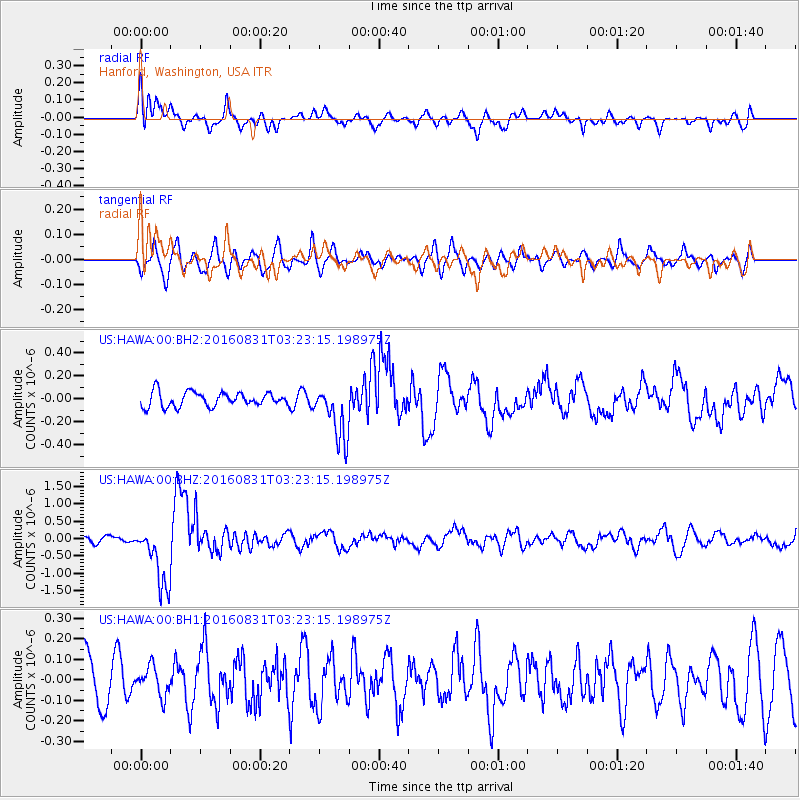
HAWA Hanford, Washington, USA - Earthquake Result Viewer
*The percent match for this event was below the threshold and hence no stack was calculated.
| Earthquake location: |
New Ireland Region, P.N.G. |
| Earthquake latitude/longitude: |
-3.7/152.8 |
| Earthquake time(UTC): |
2016/08/31 (244) 03:11:36 GMT |
| Earthquake Depth: |
499 km |
| Earthquake Magnitude: |
6.7 MO |
| Earthquake Catalog/Contributor: |
NEIC PDE/NEIC ALERT |
|
| Network: |
US United States National Seismic Network |
| Station: |
HAWA Hanford, Washington, USA |
| Lat/Lon: |
46.39 N/119.53 W |
| Elevation: |
364 m |
|
| Distance: |
91.0 deg |
| Az: |
43.764 deg |
| Baz: |
265.788 deg |
| Ray Param: |
$rayparam |
*The percent match for this event was below the threshold and hence was not used in the summary stack. |
|
| Radial Match: |
74.67822 % |
| Radial Bump: |
400 |
| Transverse Match: |
63.058315 % |
| Transverse Bump: |
400 |
| SOD ConfigId: |
1634031 |
| Insert Time: |
2016-09-14 03:13:42.615 +0000 |
| GWidth: |
2.5 |
| Max Bumps: |
400 |
| Tol: |
0.001 |
|
Signal To Noise
| Channel | StoN | STA | LTA |
| US:HAWA:00:BHZ:20160831T03:23:15.198975Z | 9.569216 | 8.963022E-7 | 9.3665165E-8 |
| US:HAWA:00:BH1:20160831T03:23:15.198975Z | 0.6497154 | 7.076249E-8 | 1.0891305E-7 |
| US:HAWA:00:BH2:20160831T03:23:15.198975Z | 3.8987424 | 2.4102326E-7 | 6.182077E-8 |
| Arrivals |
| Ps | |
| PpPs | |
| PsPs/PpSs | |


