You are here: Home > Network List > TA - USArray Transportable Network (new EarthScope stations) Stations List
> Station F21K Alatna River, AK, USA > Earthquake Result Viewer
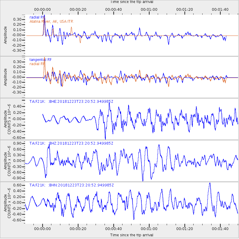
F21K Alatna River, AK, USA - Earthquake Result Viewer
*The percent match for this event was below the threshold and hence no stack was calculated.
| Earthquake location: |
Tonga Islands |
| Earthquake latitude/longitude: |
-20.4/-175.1 |
| Earthquake time(UTC): |
2018/12/23 (357) 23:08:40 GMT |
| Earthquake Depth: |
100 km |
| Earthquake Magnitude: |
6.4 mww |
| Earthquake Catalog/Contributor: |
NEIC PDE/us |
|
| Network: |
TA USArray Transportable Network (new EarthScope stations) |
| Station: |
F21K Alatna River, AK, USA |
| Lat/Lon: |
67.22 N/153.48 W |
| Elevation: |
597 m |
|
| Distance: |
88.8 deg |
| Az: |
8.246 deg |
| Baz: |
200.218 deg |
| Ray Param: |
$rayparam |
*The percent match for this event was below the threshold and hence was not used in the summary stack. |
|
| Radial Match: |
41.049274 % |
| Radial Bump: |
371 |
| Transverse Match: |
58.878162 % |
| Transverse Bump: |
400 |
| SOD ConfigId: |
13570011 |
| Insert Time: |
2019-05-02 03:56:15.903 +0000 |
| GWidth: |
2.5 |
| Max Bumps: |
400 |
| Tol: |
0.001 |
|
Signal To Noise
| Channel | StoN | STA | LTA |
| TA:F21K: :BHZ:20181223T23:20:52.949985Z | 3.059986 | 4.900473E-7 | 1.601469E-7 |
| TA:F21K: :BHN:20181223T23:20:52.949985Z | 0.98047626 | 9.821471E-8 | 1.0017042E-7 |
| TA:F21K: :BHE:20181223T23:20:52.949985Z | 2.566014 | 1.8568946E-7 | 7.236494E-8 |
| Arrivals |
| Ps | |
| PpPs | |
| PsPs/PpSs | |


