You are here: Home > Network List > TA - USArray Transportable Network (new EarthScope stations) Stations List
> Station E17A Martinsdale, MT, USA > Earthquake Result Viewer
E17A Martinsdale, MT, USA - Earthquake Result Viewer
*The percent match for this event was below the threshold and hence no stack was calculated.
| Earthquake location: |
Solomon Islands |
| Earthquake latitude/longitude: |
-6.5/155.0 |
| Earthquake time(UTC): |
2009/07/25 (206) 01:42:23 GMT |
| Earthquake Depth: |
32 km |
| Earthquake Magnitude: |
5.9 MB, 5.7 MS, 5.9 MW, 5.9 MW |
| Earthquake Catalog/Contributor: |
WHDF/NEIC |
|
| Network: |
TA USArray Transportable Network (new EarthScope stations) |
| Station: |
E17A Martinsdale, MT, USA |
| Lat/Lon: |
46.46 N/110.86 W |
| Elevation: |
1835 m |
|
| Distance: |
97.5 deg |
| Az: |
44.062 deg |
| Baz: |
268.53 deg |
| Ray Param: |
$rayparam |
*The percent match for this event was below the threshold and hence was not used in the summary stack. |
|
| Radial Match: |
25.000303 % |
| Radial Bump: |
276 |
| Transverse Match: |
23.564367 % |
| Transverse Bump: |
192 |
| SOD ConfigId: |
2648 |
| Insert Time: |
2010-03-06 18:53:52.952 +0000 |
| GWidth: |
2.5 |
| Max Bumps: |
400 |
| Tol: |
0.001 |
|
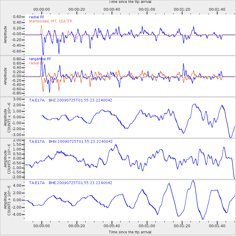
Signal To Noise
| Channel | StoN | STA | LTA |
| TA:E17A: :BHN:20090725T01:55:23.224004Z | 0.40891147 | 2.1254647E-7 | 5.19786E-7 |
| TA:E17A: :BHE:20090725T01:55:23.224004Z | 1.2788465 | 9.2560424E-7 | 7.2378054E-7 |
| TA:E17A: :BHZ:20090725T01:55:23.224004Z | 3.3309326 | 9.0233715E-7 | 2.7089624E-7 |
| Arrivals |
| Ps | |
| PpPs | |
| PsPs/PpSs | |


