You are here: Home > Network List > TA - USArray Transportable Network (new EarthScope stations) Stations List
> Station J26L Joseph Creek, AK, USA > Earthquake Result Viewer
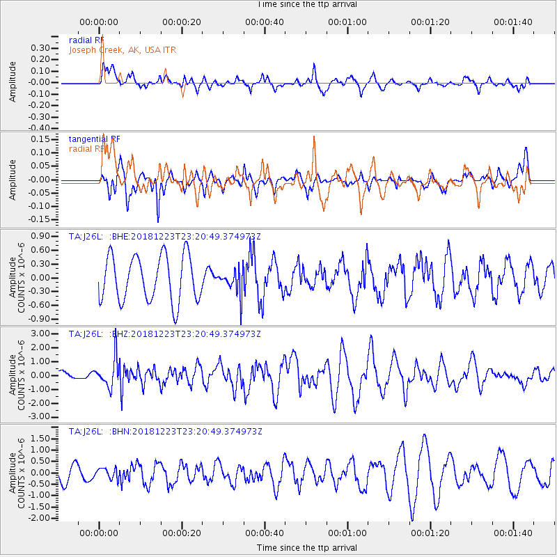
J26L Joseph Creek, AK, USA - Earthquake Result Viewer
*The percent match for this event was below the threshold and hence no stack was calculated.
| Earthquake location: |
Tonga Islands |
| Earthquake latitude/longitude: |
-20.4/-175.1 |
| Earthquake time(UTC): |
2018/12/23 (357) 23:08:40 GMT |
| Earthquake Depth: |
100 km |
| Earthquake Magnitude: |
6.4 mww |
| Earthquake Catalog/Contributor: |
NEIC PDE/us |
|
| Network: |
TA USArray Transportable Network (new EarthScope stations) |
| Station: |
J26L Joseph Creek, AK, USA |
| Lat/Lon: |
64.50 N/143.56 W |
| Elevation: |
1144 m |
|
| Distance: |
88.0 deg |
| Az: |
13.09 deg |
| Baz: |
209.399 deg |
| Ray Param: |
$rayparam |
*The percent match for this event was below the threshold and hence was not used in the summary stack. |
|
| Radial Match: |
64.76201 % |
| Radial Bump: |
344 |
| Transverse Match: |
41.262405 % |
| Transverse Bump: |
327 |
| SOD ConfigId: |
13570011 |
| Insert Time: |
2019-05-02 03:56:41.968 +0000 |
| GWidth: |
2.5 |
| Max Bumps: |
400 |
| Tol: |
0.001 |
|
Signal To Noise
| Channel | StoN | STA | LTA |
| TA:J26L: :BHZ:20181223T23:20:49.374973Z | 3.488112 | 1.0512224E-6 | 3.013729E-7 |
| TA:J26L: :BHN:20181223T23:20:49.374973Z | 0.5648106 | 2.346284E-7 | 4.1541077E-7 |
| TA:J26L: :BHE:20181223T23:20:49.374973Z | 0.24792789 | 1.2373614E-7 | 4.990812E-7 |
| Arrivals |
| Ps | |
| PpPs | |
| PsPs/PpSs | |


