You are here: Home > Network List > TA - USArray Transportable Network (new EarthScope stations) Stations List
> Station R33M Jennings River, BC, CAN > Earthquake Result Viewer
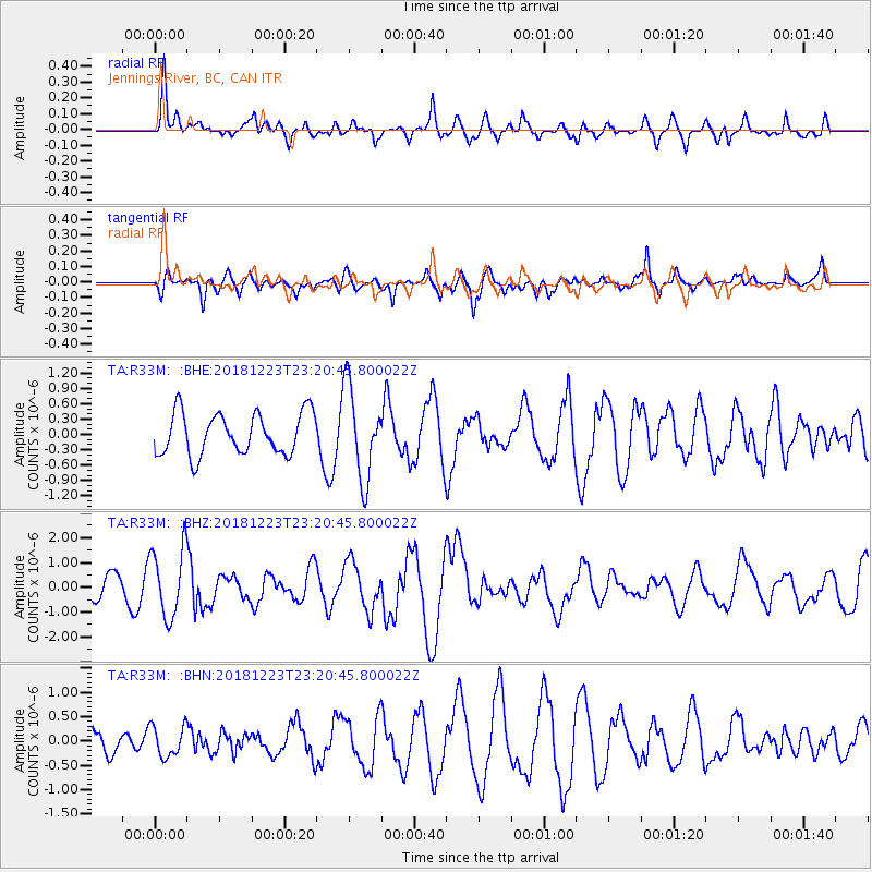
R33M Jennings River, BC, CAN - Earthquake Result Viewer
*The percent match for this event was below the threshold and hence no stack was calculated.
| Earthquake location: |
Tonga Islands |
| Earthquake latitude/longitude: |
-20.4/-175.1 |
| Earthquake time(UTC): |
2018/12/23 (357) 23:08:40 GMT |
| Earthquake Depth: |
100 km |
| Earthquake Magnitude: |
6.4 mww |
| Earthquake Catalog/Contributor: |
NEIC PDE/us |
|
| Network: |
TA USArray Transportable Network (new EarthScope stations) |
| Station: |
R33M Jennings River, BC, CAN |
| Lat/Lon: |
59.39 N/130.97 W |
| Elevation: |
1437 m |
|
| Distance: |
87.3 deg |
| Az: |
20.893 deg |
| Baz: |
220.838 deg |
| Ray Param: |
$rayparam |
*The percent match for this event was below the threshold and hence was not used in the summary stack. |
|
| Radial Match: |
61.868504 % |
| Radial Bump: |
400 |
| Transverse Match: |
61.67733 % |
| Transverse Bump: |
400 |
| SOD ConfigId: |
13570011 |
| Insert Time: |
2019-05-02 03:57:22.030 +0000 |
| GWidth: |
2.5 |
| Max Bumps: |
400 |
| Tol: |
0.001 |
|
Signal To Noise
| Channel | StoN | STA | LTA |
| TA:R33M: :BHZ:20181223T23:20:45.800022Z | 3.7426286 | 1.379597E-6 | 3.6861712E-7 |
| TA:R33M: :BHN:20181223T23:20:45.800022Z | 0.9199902 | 3.1641116E-7 | 3.4392883E-7 |
| TA:R33M: :BHE:20181223T23:20:45.800022Z | 2.3057728 | 9.0945883E-7 | 3.9442693E-7 |
| Arrivals |
| Ps | |
| PpPs | |
| PsPs/PpSs | |


