You are here: Home > Network List > TX - Texas Seismological Network Stations List
> Station WTFS Witchita Falls > Earthquake Result Viewer
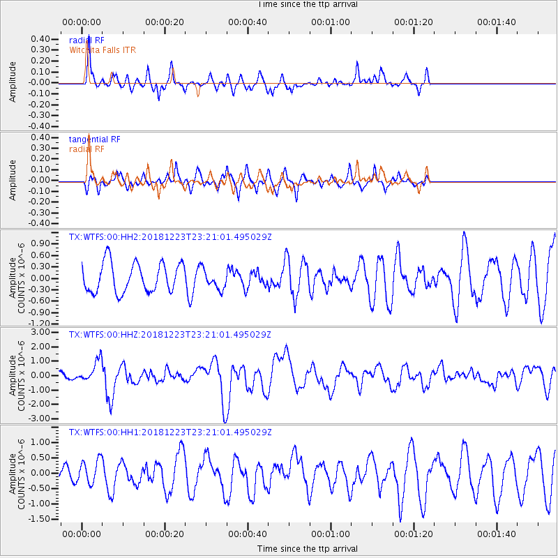
WTFS Witchita Falls - Earthquake Result Viewer
*The percent match for this event was below the threshold and hence no stack was calculated.
| Earthquake location: |
Tonga Islands |
| Earthquake latitude/longitude: |
-20.4/-175.1 |
| Earthquake time(UTC): |
2018/12/23 (357) 23:08:40 GMT |
| Earthquake Depth: |
100 km |
| Earthquake Magnitude: |
6.4 mww |
| Earthquake Catalog/Contributor: |
NEIC PDE/us |
|
| Network: |
TX Texas Seismological Network |
| Station: |
WTFS Witchita Falls |
| Lat/Lon: |
33.77 N/98.46 W |
| Elevation: |
277 m |
|
| Distance: |
90.6 deg |
| Az: |
54.144 deg |
| Baz: |
245.897 deg |
| Ray Param: |
$rayparam |
*The percent match for this event was below the threshold and hence was not used in the summary stack. |
|
| Radial Match: |
57.886894 % |
| Radial Bump: |
336 |
| Transverse Match: |
58.86568 % |
| Transverse Bump: |
381 |
| SOD ConfigId: |
13570011 |
| Insert Time: |
2019-05-02 03:58:23.272 +0000 |
| GWidth: |
2.5 |
| Max Bumps: |
400 |
| Tol: |
0.001 |
|
Signal To Noise
| Channel | StoN | STA | LTA |
| TX:WTFS:00:HHZ:20181223T23:21:01.495029Z | 2.5979338 | 7.9062215E-7 | 3.0432727E-7 |
| TX:WTFS:00:HH1:20181223T23:21:01.495029Z | 1.1653585 | 4.0267827E-7 | 3.4554023E-7 |
| TX:WTFS:00:HH2:20181223T23:21:01.495029Z | 0.6864785 | 2.5984556E-7 | 3.785196E-7 |
| Arrivals |
| Ps | |
| PpPs | |
| PsPs/PpSs | |


