You are here: Home > Network List > UW - Pacific Northwest Regional Seismic Network Stations List
> Station YACT Amboy, WA, USA > Earthquake Result Viewer
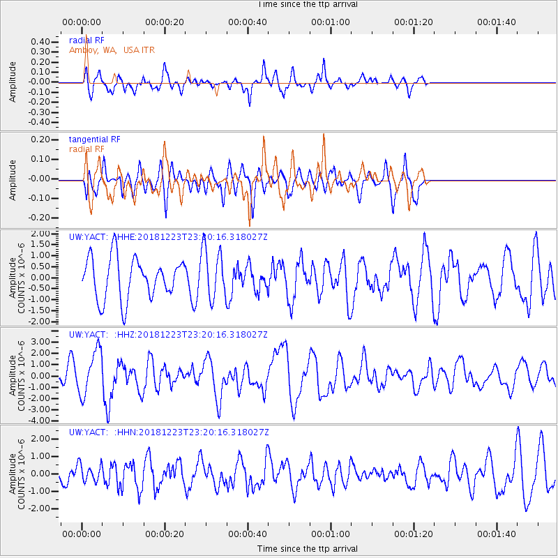
YACT Amboy, WA, USA - Earthquake Result Viewer
*The percent match for this event was below the threshold and hence no stack was calculated.
| Earthquake location: |
Tonga Islands |
| Earthquake latitude/longitude: |
-20.4/-175.1 |
| Earthquake time(UTC): |
2018/12/23 (357) 23:08:40 GMT |
| Earthquake Depth: |
100 km |
| Earthquake Magnitude: |
6.4 mww |
| Earthquake Catalog/Contributor: |
NEIC PDE/us |
|
| Network: |
UW Pacific Northwest Regional Seismic Network |
| Station: |
YACT Amboy, WA, USA |
| Lat/Lon: |
45.93 N/122.42 W |
| Elevation: |
211 m |
|
| Distance: |
81.4 deg |
| Az: |
34.142 deg |
| Baz: |
228.98 deg |
| Ray Param: |
$rayparam |
*The percent match for this event was below the threshold and hence was not used in the summary stack. |
|
| Radial Match: |
62.390736 % |
| Radial Bump: |
391 |
| Transverse Match: |
40.551525 % |
| Transverse Bump: |
377 |
| SOD ConfigId: |
13570011 |
| Insert Time: |
2019-05-02 03:59:02.425 +0000 |
| GWidth: |
2.5 |
| Max Bumps: |
400 |
| Tol: |
0.001 |
|
Signal To Noise
| Channel | StoN | STA | LTA |
| UW:YACT: :HHZ:20181223T23:20:16.318027Z | 3.4466596 | 2.0200728E-6 | 5.8609584E-7 |
| UW:YACT: :HHN:20181223T23:20:16.318027Z | 0.5340839 | 4.970815E-7 | 9.30718E-7 |
| UW:YACT: :HHE:20181223T23:20:16.318027Z | 1.239623 | 1.1654287E-6 | 9.401477E-7 |
| Arrivals |
| Ps | |
| PpPs | |
| PsPs/PpSs | |


