You are here: Home > Network List > TS - TERRAscope (Southern California Seismic Network) Stations List
> Station CALB Calabasas, California, USA > Earthquake Result Viewer
CALB Calabasas, California, USA - Earthquake Result Viewer
| Earthquake location: |
Santiago Del Estero Prov., Arg. |
| Earthquake latitude/longitude: |
-28.5/-63.1 |
| Earthquake time(UTC): |
1994/05/10 (130) 06:36:28 GMT |
| Earthquake Depth: |
605 km |
| Earthquake Magnitude: |
6.4 MB, 6.2 UNKNOWN, 6.9 MW |
| Earthquake Catalog/Contributor: |
WHDF/NEIC |
|
| Network: |
TS TERRAscope (Southern California Seismic Network) |
| Station: |
CALB Calabasas, California, USA |
| Lat/Lon: |
34.14 N/118.63 W |
| Elevation: |
0.0 m |
|
| Distance: |
81.5 deg |
| Az: |
316.24 deg |
| Baz: |
132.778 deg |
| Ray Param: |
0.045686647 |
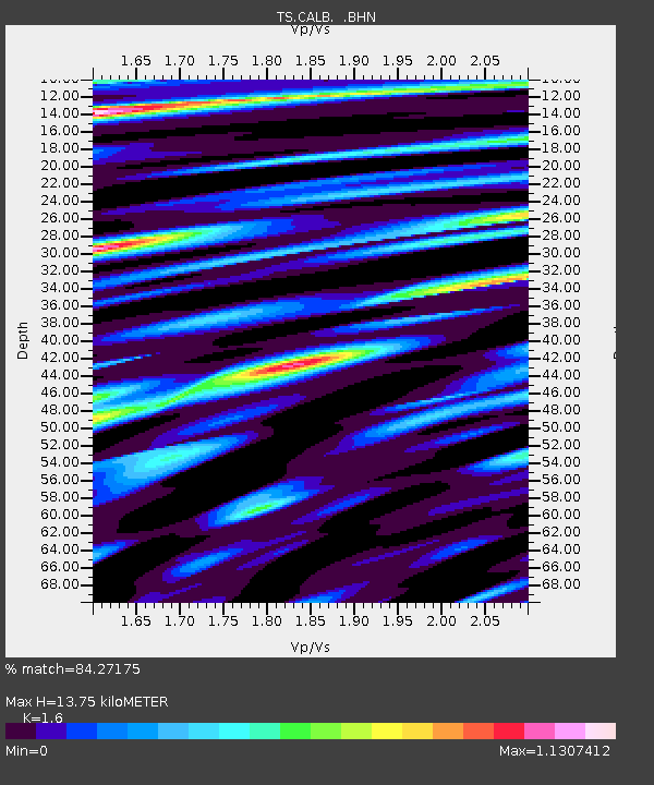
| Estimated Moho Depth: |
13.75 km |
| Estimated Crust Vp/Vs: |
1.60 |
| Assumed Crust Vp: |
6.1 km/s |
| Estimated Crust Vs: |
3.812 km/s |
| Estimated Crust Poisson's Ratio: |
0.18 |
|
| Radial Match: |
84.27175 % |
| Radial Bump: |
400 |
| Transverse Match: |
85.39828 % |
| Transverse Bump: |
400 |
| SOD ConfigId: |
16938 |
| Insert Time: |
2010-02-26 14:02:29.138 +0000 |
| GWidth: |
2.5 |
| Max Bumps: |
400 |
| Tol: |
0.001 |
|

Signal To Noise
| Channel | StoN | STA | LTA |
| TS:CALB: :BHN:19940510T06:47:13.001025Z | 1.2819114 | 4.8632097E-7 | 3.7937176E-7 |
| TS:CALB: :BHE:19940510T06:47:13.001025Z | 4.6155357 | 1.2600459E-6 | 2.7300104E-7 |
| TS:CALB: :BHZ:19940510T06:47:13.001025Z | 15.364639 | 3.207175E-6 | 2.0873742E-7 |
| Arrivals |
| Ps | 1.4 SECOND |
| PpPs | 5.7 SECOND |
| PsPs/PpSs | 7.1 SECOND |


