You are here: Home > Network List > IU - Global Seismograph Network (GSN - IRIS/USGS) Stations List
> Station PMG Port Moresby, New Guinea > Earthquake Result Viewer
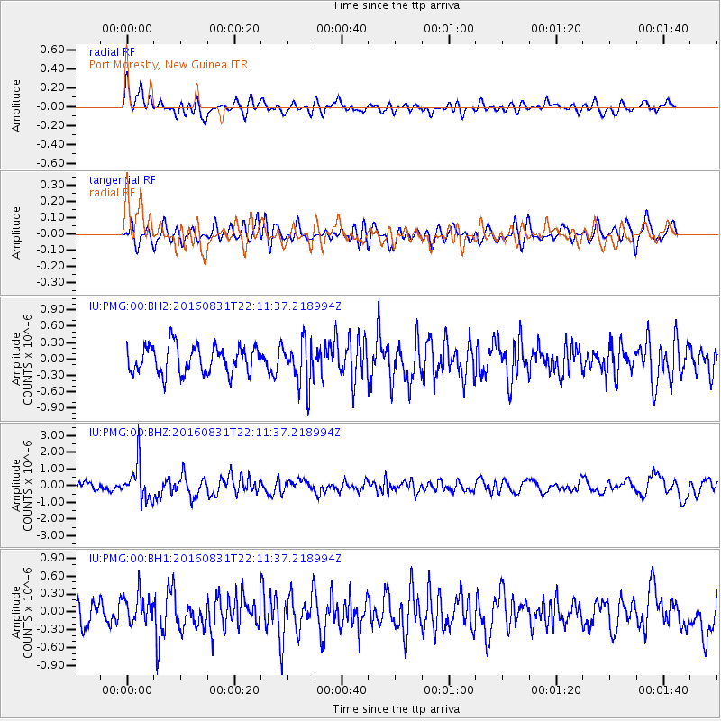
PMG Port Moresby, New Guinea - Earthquake Result Viewer
*The percent match for this event was below the threshold and hence no stack was calculated.
| Earthquake location: |
Off E. Coast Of N. Island, N.Z. |
| Earthquake latitude/longitude: |
-37.2/179.1 |
| Earthquake time(UTC): |
2016/08/31 (244) 22:04:35 GMT |
| Earthquake Depth: |
22 km |
| Earthquake Magnitude: |
5.8 MB |
| Earthquake Catalog/Contributor: |
NEIC PDE/NEIC ALERT |
|
| Network: |
IU Global Seismograph Network (GSN - IRIS/USGS) |
| Station: |
PMG Port Moresby, New Guinea |
| Lat/Lon: |
9.40 S/147.16 E |
| Elevation: |
90 m |
|
| Distance: |
40.0 deg |
| Az: |
305.633 deg |
| Baz: |
138.88 deg |
| Ray Param: |
$rayparam |
*The percent match for this event was below the threshold and hence was not used in the summary stack. |
|
| Radial Match: |
64.29842 % |
| Radial Bump: |
400 |
| Transverse Match: |
45.46292 % |
| Transverse Bump: |
400 |
| SOD ConfigId: |
1634031 |
| Insert Time: |
2016-09-14 22:05:34.814 +0000 |
| GWidth: |
2.5 |
| Max Bumps: |
400 |
| Tol: |
0.001 |
|
Signal To Noise
| Channel | StoN | STA | LTA |
| IU:PMG:00:BHZ:20160831T22:11:37.218994Z | 5.3523893 | 1.0978671E-6 | 2.0511719E-7 |
| IU:PMG:00:BH1:20160831T22:11:37.218994Z | 1.3898275 | 2.4767726E-7 | 1.7820719E-7 |
| IU:PMG:00:BH2:20160831T22:11:37.218994Z | 1.640609 | 4.0813512E-7 | 2.487705E-7 |
| Arrivals |
| Ps | |
| PpPs | |
| PsPs/PpSs | |


