You are here: Home > Network List > TS - TERRAscope (Southern California Seismic Network) Stations List
> Station CALB Calabasas, California, USA > Earthquake Result Viewer
CALB Calabasas, California, USA - Earthquake Result Viewer
| Earthquake location: |
Northern Bolivia |
| Earthquake latitude/longitude: |
-13.8/-67.6 |
| Earthquake time(UTC): |
1994/06/09 (160) 00:33:16 GMT |
| Earthquake Depth: |
637 km |
| Earthquake Magnitude: |
6.9 MB, 6.8 MS, 8.3 UNKNOWN, 8.2 MW |
| Earthquake Catalog/Contributor: |
WHDF/NEIC |
|
| Network: |
TS TERRAscope (Southern California Seismic Network) |
| Station: |
CALB Calabasas, California, USA |
| Lat/Lon: |
34.14 N/118.63 W |
| Elevation: |
0.0 m |
|
| Distance: |
68.1 deg |
| Az: |
315.934 deg |
| Baz: |
125.458 deg |
| Ray Param: |
0.05422246 |
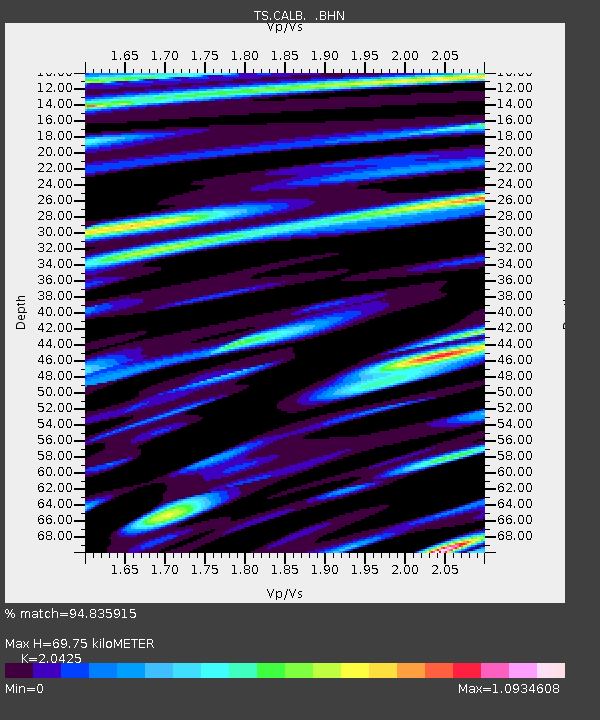
| Estimated Moho Depth: |
69.75 km |
| Estimated Crust Vp/Vs: |
2.04 |
| Assumed Crust Vp: |
6.1 km/s |
| Estimated Crust Vs: |
2.987 km/s |
| Estimated Crust Poisson's Ratio: |
0.34 |
|
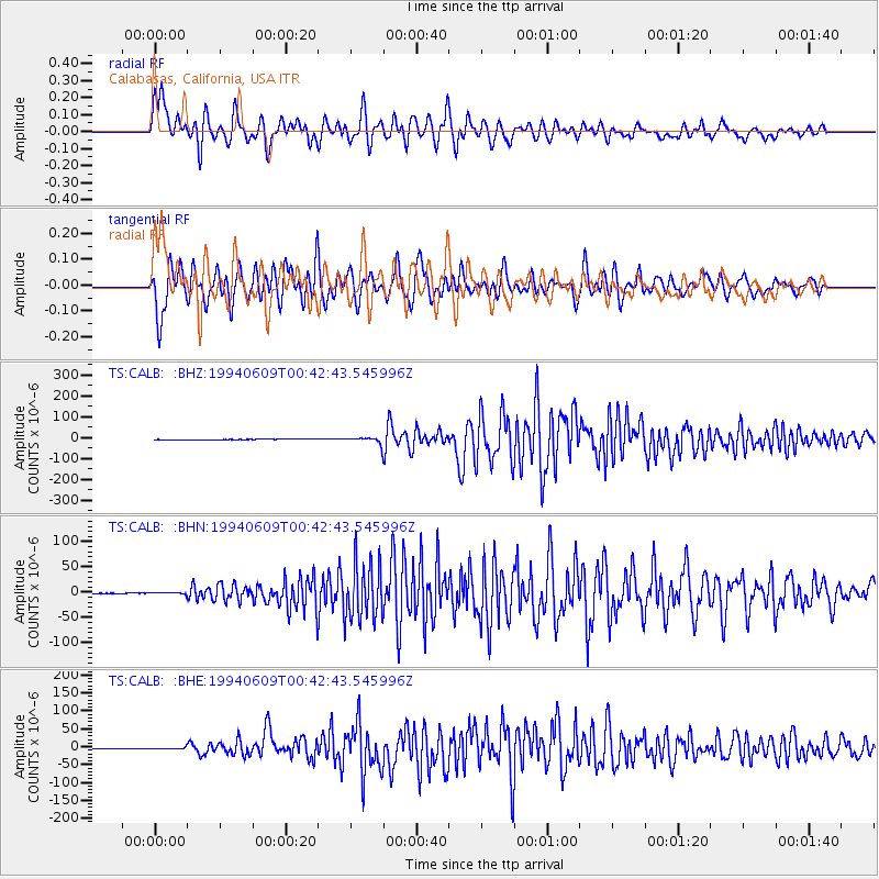
| Radial Match: |
94.835915 % |
| Radial Bump: |
400 |
| Transverse Match: |
96.66275 % |
| Transverse Bump: |
400 |
| SOD ConfigId: |
16938 |
| Insert Time: |
2010-02-26 14:02:31.667 +0000 |
| GWidth: |
2.5 |
| Max Bumps: |
400 |
| Tol: |
0.001 |
|
Signal To Noise
| Channel | StoN | STA | LTA |
| TS:CALB: :BHN:19940609T00:42:43.545996Z | 1.7605652 | 1.3935726E-6 | 7.915484E-7 |
| TS:CALB: :BHE:19940609T00:42:43.545996Z | 2.316617 | 1.8510264E-6 | 7.990212E-7 |
| TS:CALB: :BHZ:19940609T00:42:43.545996Z | 17.773584 | 1.6280565E-5 | 9.159979E-7 |
| Arrivals |
| Ps | 12 SECOND |
| PpPs | 34 SECOND |
| PsPs/PpSs | 46 SECOND |


