You are here: Home > Network List > UU - University of Utah Regional Network Stations List
> Station FORU South Mineral Mountains, UT, USA > Earthquake Result Viewer
FORU South Mineral Mountains, UT, USA - Earthquake Result Viewer
*The percent match for this event was below the threshold and hence no stack was calculated.
| Earthquake location: |
Off E. Coast Of N. Island, N.Z. |
| Earthquake latitude/longitude: |
-37.2/179.1 |
| Earthquake time(UTC): |
2016/08/31 (244) 22:04:35 GMT |
| Earthquake Depth: |
22 km |
| Earthquake Magnitude: |
5.8 MB |
| Earthquake Catalog/Contributor: |
NEIC PDE/NEIC ALERT |
|
| Network: |
UU University of Utah Regional Network |
| Station: |
FORU South Mineral Mountains, UT, USA |
| Lat/Lon: |
38.46 N/112.86 W |
| Elevation: |
1840 m |
|
| Distance: |
97.9 deg |
| Az: |
47.311 deg |
| Baz: |
228.376 deg |
| Ray Param: |
$rayparam |
*The percent match for this event was below the threshold and hence was not used in the summary stack. |
|
| Radial Match: |
49.631092 % |
| Radial Bump: |
400 |
| Transverse Match: |
53.467686 % |
| Transverse Bump: |
400 |
| SOD ConfigId: |
1634031 |
| Insert Time: |
2016-09-14 22:05:53.923 +0000 |
| GWidth: |
2.5 |
| Max Bumps: |
400 |
| Tol: |
0.001 |
|
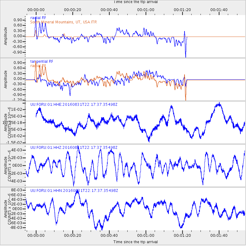
Signal To Noise
| Channel | StoN | STA | LTA |
| UU:FORU:01:HHZ:20160831T22:17:37.35498Z | 0.41677558 | 9.455577E-10 | 2.2687456E-9 |
| UU:FORU:01:HHN:20160831T22:17:37.35498Z | 0.8121966 | 4.4064925E-9 | 5.4254015E-9 |
| UU:FORU:01:HHE:20160831T22:17:37.35498Z | 0.60849345 | 2.9357026E-9 | 4.824543E-9 |
| Arrivals |
| Ps | |
| PpPs | |
| PsPs/PpSs | |


