You are here: Home > Network List > G - GEOSCOPE Stations List
> Station DRV Dumont d'Urville, Terre Adelie (Antartica) > Earthquake Result Viewer
DRV Dumont d'Urville, Terre Adelie (Antartica) - Earthquake Result Viewer
| Earthquake location: |
Off E. Coast Of N. Island, N.Z. |
| Earthquake latitude/longitude: |
-37.4/179.1 |
| Earthquake time(UTC): |
2016/09/01 (245) 16:37:57 GMT |
| Earthquake Depth: |
19 km |
| Earthquake Magnitude: |
7.1 MWW, 7.0 MWW, 7.2 MI |
| Earthquake Catalog/Contributor: |
NEIC PDE/NEIC COMCAT |
|
| Network: |
G GEOSCOPE |
| Station: |
DRV Dumont d'Urville, Terre Adelie (Antartica) |
| Lat/Lon: |
66.67 S/140.01 E |
| Elevation: |
40 m |
|
| Distance: |
36.8 deg |
| Az: |
204.789 deg |
| Baz: |
56.952 deg |
| Ray Param: |
0.07648264 |
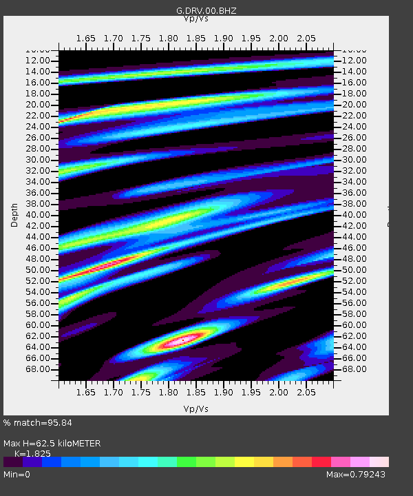
| Estimated Moho Depth: |
62.5 km |
| Estimated Crust Vp/Vs: |
1.83 |
| Assumed Crust Vp: |
6.39 km/s |
| Estimated Crust Vs: |
3.501 km/s |
| Estimated Crust Poisson's Ratio: |
0.29 |
|
| Radial Match: |
95.84 % |
| Radial Bump: |
269 |
| Transverse Match: |
88.58864 % |
| Transverse Bump: |
400 |
| SOD ConfigId: |
1634031 |
| Insert Time: |
2016-09-15 16:38:54.974 +0000 |
| GWidth: |
2.5 |
| Max Bumps: |
400 |
| Tol: |
0.001 |
|
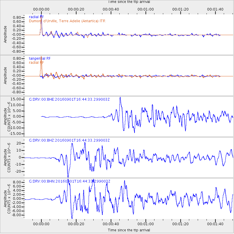
Signal To Noise
| Channel | StoN | STA | LTA |
| G:DRV:00:BHZ:20160901T16:44:33.299003Z | 1.7976576 | 2.2599738E-7 | 1.257177E-7 |
| G:DRV:00:BHN:20160901T16:44:33.299003Z | 0.8012365 | 1.4360961E-7 | 1.7923497E-7 |
| G:DRV:00:BHE:20160901T16:44:33.299003Z | 1.0139878 | 2.764038E-7 | 2.7259085E-7 |
| Arrivals |
| Ps | 8.7 SECOND |
| PpPs | 26 SECOND |
| PsPs/PpSs | 34 SECOND |


