You are here: Home > Network List > TA - USArray Transportable Network (new EarthScope stations) Stations List
> Station E20K Nigu River, AK, USA > Earthquake Result Viewer
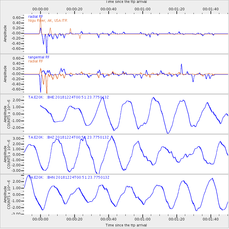
E20K Nigu River, AK, USA - Earthquake Result Viewer
*The percent match for this event was below the threshold and hence no stack was calculated.
| Earthquake location: |
Off East Coast Of Honshu, Japan |
| Earthquake latitude/longitude: |
34.1/141.7 |
| Earthquake time(UTC): |
2018/12/24 (358) 00:43:10 GMT |
| Earthquake Depth: |
6.9 km |
| Earthquake Magnitude: |
5.5 Mww |
| Earthquake Catalog/Contributor: |
NEIC PDE/us |
|
| Network: |
TA USArray Transportable Network (new EarthScope stations) |
| Station: |
E20K Nigu River, AK, USA |
| Lat/Lon: |
68.26 N/156.19 W |
| Elevation: |
866 m |
|
| Distance: |
48.6 deg |
| Az: |
26.067 deg |
| Baz: |
258.274 deg |
| Ray Param: |
$rayparam |
*The percent match for this event was below the threshold and hence was not used in the summary stack. |
|
| Radial Match: |
92.35421 % |
| Radial Bump: |
380 |
| Transverse Match: |
52.423115 % |
| Transverse Bump: |
400 |
| SOD ConfigId: |
13570011 |
| Insert Time: |
2019-05-02 04:14:15.699 +0000 |
| GWidth: |
2.5 |
| Max Bumps: |
400 |
| Tol: |
0.001 |
|
Signal To Noise
| Channel | StoN | STA | LTA |
| TA:E20K: :BHZ:20181224T00:51:23.775013Z | 2.4394903 | 2.5093552E-6 | 1.0286391E-6 |
| TA:E20K: :BHN:20181224T00:51:23.775013Z | 0.7807297 | 1.7238466E-6 | 2.2079942E-6 |
| TA:E20K: :BHE:20181224T00:51:23.775013Z | 1.2765968 | 1.0577057E-6 | 8.285355E-7 |
| Arrivals |
| Ps | |
| PpPs | |
| PsPs/PpSs | |


