You are here: Home > Network List > TA - USArray Transportable Network (new EarthScope stations) Stations List
> Station F14K Arctic Creek, AK, USA > Earthquake Result Viewer
F14K Arctic Creek, AK, USA - Earthquake Result Viewer
| Earthquake location: |
Off East Coast Of Honshu, Japan |
| Earthquake latitude/longitude: |
34.1/141.7 |
| Earthquake time(UTC): |
2018/12/24 (358) 00:43:10 GMT |
| Earthquake Depth: |
6.9 km |
| Earthquake Magnitude: |
5.5 Mww |
| Earthquake Catalog/Contributor: |
NEIC PDE/us |
|
| Network: |
TA USArray Transportable Network (new EarthScope stations) |
| Station: |
F14K Arctic Creek, AK, USA |
| Lat/Lon: |
65.47 N/166.33 W |
| Elevation: |
266 m |
|
| Distance: |
44.0 deg |
| Az: |
28.289 deg |
| Baz: |
250.49 deg |
| Ray Param: |
0.072225876 |
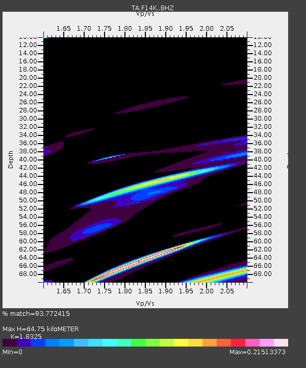
| Estimated Moho Depth: |
64.75 km |
| Estimated Crust Vp/Vs: |
1.83 |
| Assumed Crust Vp: |
6.307 km/s |
| Estimated Crust Vs: |
3.442 km/s |
| Estimated Crust Poisson's Ratio: |
0.29 |
|
| Radial Match: |
93.772415 % |
| Radial Bump: |
270 |
| Transverse Match: |
87.31883 % |
| Transverse Bump: |
281 |
| SOD ConfigId: |
13570011 |
| Insert Time: |
2019-05-02 04:14:17.155 +0000 |
| GWidth: |
2.5 |
| Max Bumps: |
400 |
| Tol: |
0.001 |
|
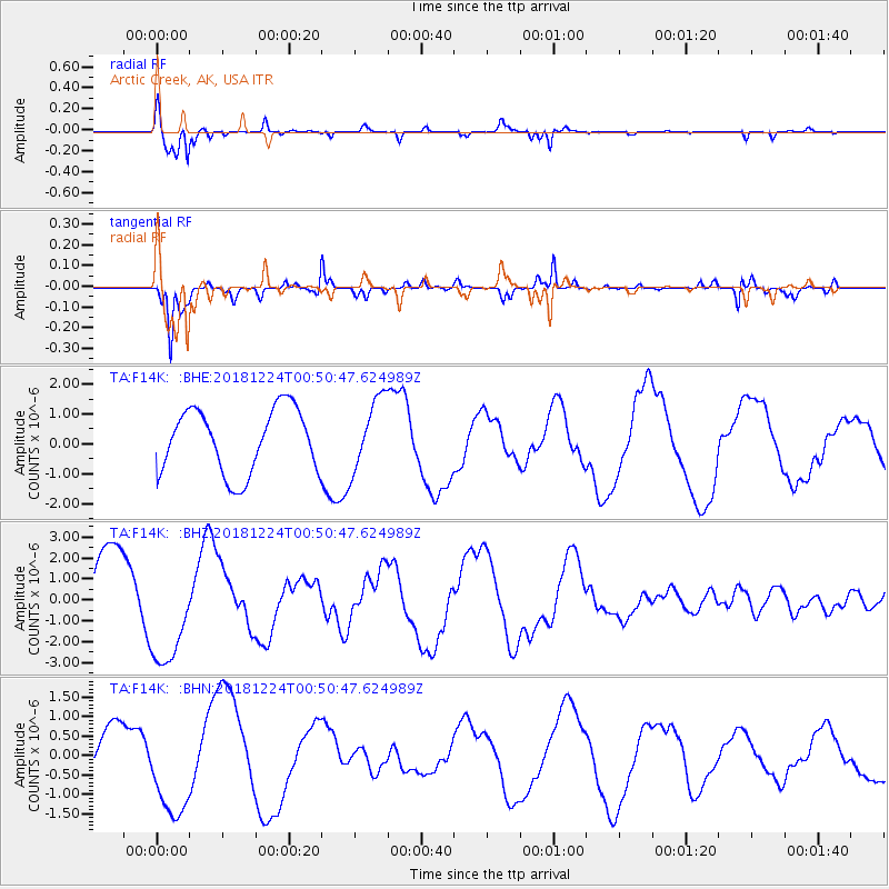
Signal To Noise
| Channel | StoN | STA | LTA |
| TA:F14K: :BHZ:20181224T00:50:47.624989Z | 1.2569052 | 2.5343265E-6 | 2.0163227E-6 |
| TA:F14K: :BHN:20181224T00:50:47.624989Z | 1.820294 | 1.2272883E-6 | 6.742253E-7 |
| TA:F14K: :BHE:20181224T00:50:47.624989Z | 1.1306921 | 1.2103368E-6 | 1.0704389E-6 |
| Arrivals |
| Ps | 9.1 SECOND |
| PpPs | 27 SECOND |
| PsPs/PpSs | 36 SECOND |


