You are here: Home > Network List > TA - USArray Transportable Network (new EarthScope stations) Stations List
> Station M21A Separation Peak, Rawlins, WY, USA > Earthquake Result Viewer
M21A Separation Peak, Rawlins, WY, USA - Earthquake Result Viewer

| Earthquake location: |
Kodiak Island Region, Alaska |
| Earthquake latitude/longitude: |
56.5/-152.7 |
| Earthquake time(UTC): |
2009/03/30 (089) 07:13:07 GMT |
| Earthquake Depth: |
21 km |
| Earthquake Magnitude: |
5.9 MB, 5.9 MS, 5.9 MW, 5.9 MW |
| Earthquake Catalog/Contributor: |
WHDF/NEIC |
|
| Network: |
TA USArray Transportable Network (new EarthScope stations) |
| Station: |
M21A Separation Peak, Rawlins, WY, USA |
| Lat/Lon: |
41.61 N/107.36 W |
| Elevation: |
2275 m |
|
| Distance: |
32.6 deg |
| Az: |
97.704 deg |
| Baz: |
312.957 deg |
| Ray Param: |
0.07856456 |
| Estimated Moho Depth: |
50.25 km |
| Estimated Crust Vp/Vs: |
1.66 |
| Assumed Crust Vp: |
6.159 km/s |
| Estimated Crust Vs: |
3.716 km/s |
| Estimated Crust Poisson's Ratio: |
0.21 |
|
| Radial Match: |
86.234344 % |
| Radial Bump: |
370 |
| Transverse Match: |
75.74722 % |
| Transverse Bump: |
400 |
| SOD ConfigId: |
2658 |
| Insert Time: |
2010-03-06 18:55:07.473 +0000 |
| GWidth: |
2.5 |
| Max Bumps: |
400 |
| Tol: |
0.001 |
|
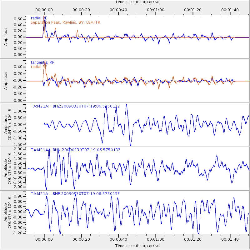
Signal To Noise
| Channel | StoN | STA | LTA |
| TA:M21A: :BHN:20090330T07:19:06.575013Z | 12.64408 | 1.1316771E-6 | 8.950252E-8 |
| TA:M21A: :BHE:20090330T07:19:06.575013Z | 4.45439 | 5.6346994E-7 | 1.2649765E-7 |
| TA:M21A: :BHZ:20090330T07:19:06.575013Z | 4.085466 | 8.3357554E-7 | 2.0403441E-7 |
| Arrivals |
| Ps | 5.8 SECOND |
| PpPs | 20 SECOND |
| PsPs/PpSs | 26 SECOND |


