You are here: Home > Network List > IU - Global Seismograph Network (GSN - IRIS/USGS) Stations List
> Station ADK Adak, Aleutian Islands, Alaska > Earthquake Result Viewer
ADK Adak, Aleutian Islands, Alaska - Earthquake Result Viewer
| Earthquake location: |
Off E. Coast Of N. Island, N.Z. |
| Earthquake latitude/longitude: |
-37.4/179.1 |
| Earthquake time(UTC): |
2016/09/01 (245) 16:37:57 GMT |
| Earthquake Depth: |
19 km |
| Earthquake Magnitude: |
7.1 MWW, 7.0 MWW, 7.2 MI |
| Earthquake Catalog/Contributor: |
NEIC PDE/NEIC COMCAT |
|
| Network: |
IU Global Seismograph Network (GSN - IRIS/USGS) |
| Station: |
ADK Adak, Aleutian Islands, Alaska |
| Lat/Lon: |
51.88 N/176.68 W |
| Elevation: |
130 m |
|
| Distance: |
89.0 deg |
| Az: |
2.64 deg |
| Baz: |
183.393 deg |
| Ray Param: |
0.042162534 |
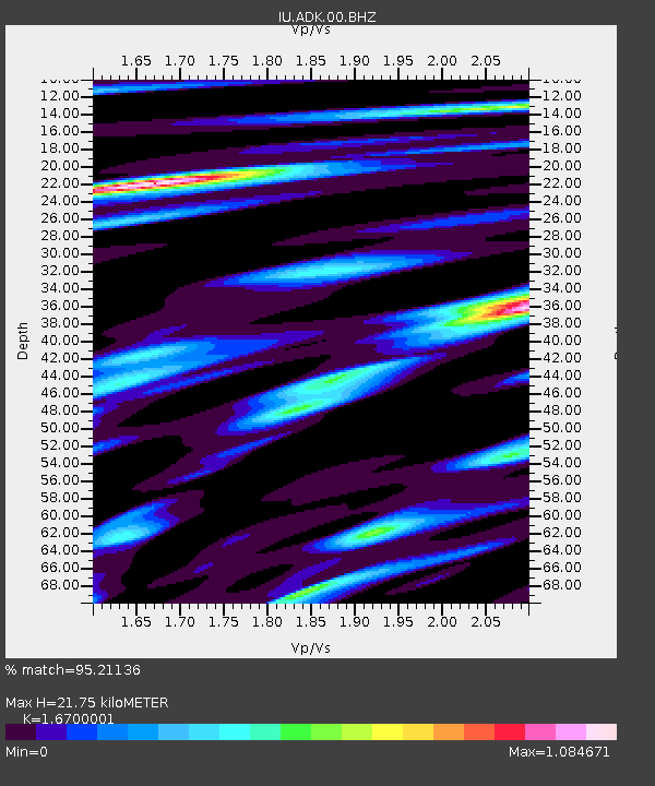
| Estimated Moho Depth: |
21.75 km |
| Estimated Crust Vp/Vs: |
1.67 |
| Assumed Crust Vp: |
5.88 km/s |
| Estimated Crust Vs: |
3.521 km/s |
| Estimated Crust Poisson's Ratio: |
0.22 |
|
| Radial Match: |
95.21136 % |
| Radial Bump: |
277 |
| Transverse Match: |
90.31697 % |
| Transverse Bump: |
400 |
| SOD ConfigId: |
1634031 |
| Insert Time: |
2016-09-15 16:39:36.840 +0000 |
| GWidth: |
2.5 |
| Max Bumps: |
400 |
| Tol: |
0.001 |
|

Signal To Noise
| Channel | StoN | STA | LTA |
| IU:ADK:00:BHZ:20160901T16:50:19.719016Z | 4.4010973 | 1.2595211E-6 | 2.8618345E-7 |
| IU:ADK:00:BH1:20160901T16:50:19.719016Z | 1.6287973 | 4.4866349E-7 | 2.7545693E-7 |
| IU:ADK:00:BH2:20160901T16:50:19.719016Z | 1.2081027 | 4.6239057E-7 | 3.8274112E-7 |
| Arrivals |
| Ps | 2.5 SECOND |
| PpPs | 9.7 SECOND |
| PsPs/PpSs | 12 SECOND |


