You are here: Home > Network List > TA - USArray Transportable Network (new EarthScope stations) Stations List
> Station M21A Separation Peak, Rawlins, WY, USA > Earthquake Result Viewer
M21A Separation Peak, Rawlins, WY, USA - Earthquake Result Viewer

| Earthquake location: |
Kuril Islands |
| Earthquake latitude/longitude: |
46.0/151.4 |
| Earthquake time(UTC): |
2009/04/18 (108) 19:17:58 GMT |
| Earthquake Depth: |
35 km |
| Earthquake Magnitude: |
6.3 MB, 6.3 MS, 6.6 MW, 6.4 MW |
| Earthquake Catalog/Contributor: |
WHDF/NEIC |
|
| Network: |
TA USArray Transportable Network (new EarthScope stations) |
| Station: |
M21A Separation Peak, Rawlins, WY, USA |
| Lat/Lon: |
41.61 N/107.36 W |
| Elevation: |
2275 m |
|
| Distance: |
68.1 deg |
| Az: |
52.447 deg |
| Baz: |
312.548 deg |
| Ray Param: |
0.056463238 |
| Estimated Moho Depth: |
41.25 km |
| Estimated Crust Vp/Vs: |
1.84 |
| Assumed Crust Vp: |
6.159 km/s |
| Estimated Crust Vs: |
3.343 km/s |
| Estimated Crust Poisson's Ratio: |
0.29 |
|
| Radial Match: |
93.72878 % |
| Radial Bump: |
329 |
| Transverse Match: |
87.019135 % |
| Transverse Bump: |
400 |
| SOD ConfigId: |
2760 |
| Insert Time: |
2010-03-06 18:55:13.161 +0000 |
| GWidth: |
2.5 |
| Max Bumps: |
400 |
| Tol: |
0.001 |
|
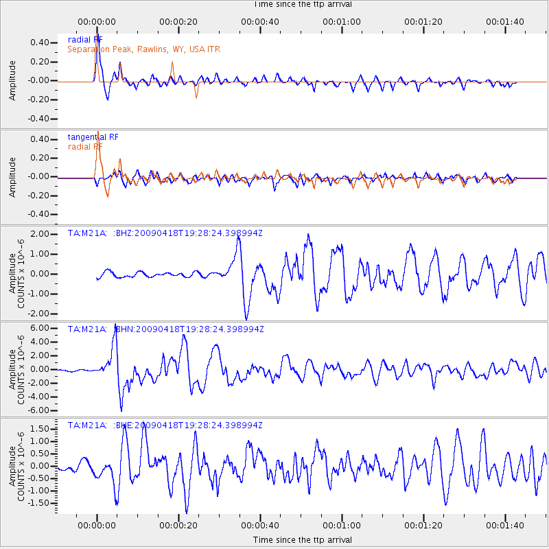
Signal To Noise
| Channel | StoN | STA | LTA |
| TA:M21A: :BHN:20090418T19:28:24.398994Z | 18.633106 | 2.5197755E-6 | 1.352311E-7 |
| TA:M21A: :BHE:20090418T19:28:24.398994Z | 3.2239892 | 5.162943E-7 | 1.6014144E-7 |
| TA:M21A: :BHZ:20090418T19:28:24.398994Z | 5.9281273 | 7.2931033E-7 | 1.2302542E-7 |
| Arrivals |
| Ps | 5.8 SECOND |
| PpPs | 18 SECOND |
| PsPs/PpSs | 24 SECOND |


