You are here: Home > Network List > TS - TERRAscope (Southern California Seismic Network) Stations List
> Station CALB Calabasas, California, USA > Earthquake Result Viewer
CALB Calabasas, California, USA - Earthquake Result Viewer
| Earthquake location: |
Off Coast Of Central America |
| Earthquake latitude/longitude: |
11.2/-88.0 |
| Earthquake time(UTC): |
1994/03/15 (074) 03:36:21 GMT |
| Earthquake Depth: |
23 km |
| Earthquake Magnitude: |
5.8 MB, 5.5 MS, 5.4 UNKNOWN, 5.6 MD |
| Earthquake Catalog/Contributor: |
WHDF/NEIC |
|
| Network: |
TS TERRAscope (Southern California Seismic Network) |
| Station: |
CALB Calabasas, California, USA |
| Lat/Lon: |
34.14 N/118.63 W |
| Elevation: |
0.0 m |
|
| Distance: |
36.1 deg |
| Az: |
314.204 deg |
| Baz: |
121.993 deg |
| Ray Param: |
0.07684759 |
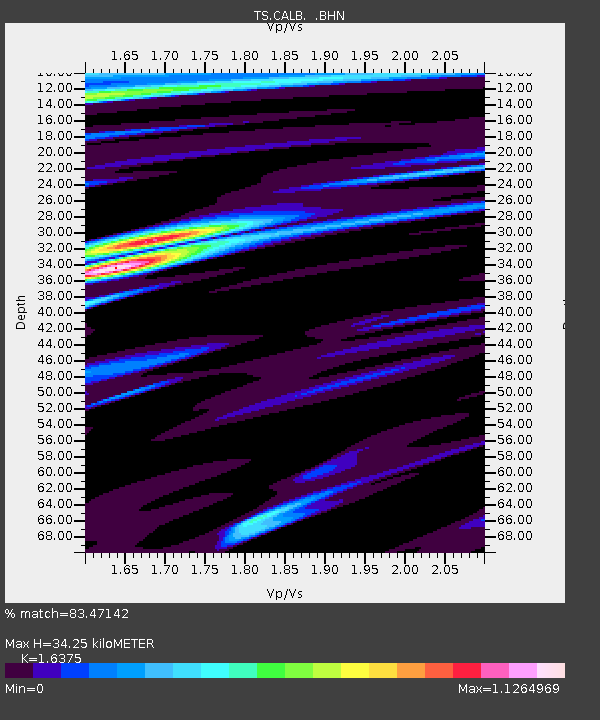
| Estimated Moho Depth: |
34.25 km |
| Estimated Crust Vp/Vs: |
1.64 |
| Assumed Crust Vp: |
6.1 km/s |
| Estimated Crust Vs: |
3.725 km/s |
| Estimated Crust Poisson's Ratio: |
0.20 |
|
| Radial Match: |
83.47142 % |
| Radial Bump: |
400 |
| Transverse Match: |
69.99196 % |
| Transverse Bump: |
400 |
| SOD ConfigId: |
17000 |
| Insert Time: |
2010-02-26 14:02:34.087 +0000 |
| GWidth: |
2.5 |
| Max Bumps: |
400 |
| Tol: |
0.001 |
|
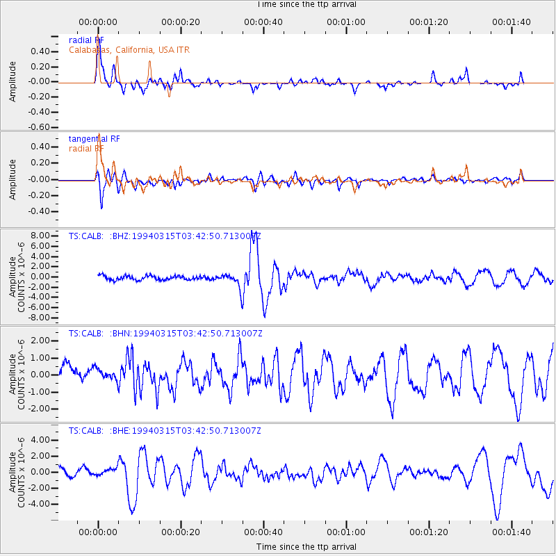
Signal To Noise
| Channel | StoN | STA | LTA |
| TS:CALB: :BHN:19940315T03:42:50.713007Z | 0.66591436 | 3.7703813E-7 | 5.6619615E-7 |
| TS:CALB: :BHE:19940315T03:42:50.713007Z | 0.99760133 | 5.5823773E-7 | 5.5958E-7 |
| TS:CALB: :BHZ:19940315T03:42:50.713007Z | 3.657066 | 1.4975304E-6 | 4.094896E-7 |
| Arrivals |
| Ps | 3.8 SECOND |
| PpPs | 14 SECOND |
| PsPs/PpSs | 18 SECOND |


