You are here: Home > Network List > KZ - Kazakhstan Network Stations List
> Station OTUK ORTAU, Kazakstan > Earthquake Result Viewer
OTUK ORTAU, Kazakstan - Earthquake Result Viewer
| Earthquake location: |
Komandorskiye Ostrova Region |
| Earthquake latitude/longitude: |
54.5/164.2 |
| Earthquake time(UTC): |
2018/12/24 (358) 10:41:39 GMT |
| Earthquake Depth: |
10 km |
| Earthquake Magnitude: |
5.4 Mww |
| Earthquake Catalog/Contributor: |
NEIC PDE/us |
|
| Network: |
KZ Kazakhstan Network |
| Station: |
OTUK ORTAU, Kazakstan |
| Lat/Lon: |
48.24 N/72.34 E |
| Elevation: |
750 m |
|
| Distance: |
53.7 deg |
| Az: |
304.057 deg |
| Baz: |
46.301 deg |
| Ray Param: |
0.06589362 |
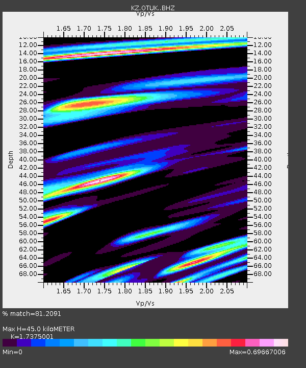
| Estimated Moho Depth: |
45.0 km |
| Estimated Crust Vp/Vs: |
1.74 |
| Assumed Crust Vp: |
6.571 km/s |
| Estimated Crust Vs: |
3.782 km/s |
| Estimated Crust Poisson's Ratio: |
0.25 |
|
| Radial Match: |
81.2091 % |
| Radial Bump: |
400 |
| Transverse Match: |
56.4229 % |
| Transverse Bump: |
400 |
| SOD ConfigId: |
13570011 |
| Insert Time: |
2019-05-02 04:20:08.430 +0000 |
| GWidth: |
2.5 |
| Max Bumps: |
400 |
| Tol: |
0.001 |
|

Signal To Noise
| Channel | StoN | STA | LTA |
| KZ:OTUK: :BHZ:20181224T10:50:27.300999Z | 5.4920917 | 5.235434E-7 | 9.5326776E-8 |
| KZ:OTUK: :BHN:20181224T10:50:27.300999Z | 3.8174827 | 2.0933663E-7 | 5.48363E-8 |
| KZ:OTUK: :BHE:20181224T10:50:27.300999Z | 3.18196 | 1.5482044E-7 | 4.865568E-8 |
| Arrivals |
| Ps | 5.4 SECOND |
| PpPs | 18 SECOND |
| PsPs/PpSs | 23 SECOND |


