You are here: Home > Network List > G - GEOSCOPE Stations List
> Station PPTF Pamatai - Papeete - Tahiti island - French Polynesia, France > Earthquake Result Viewer
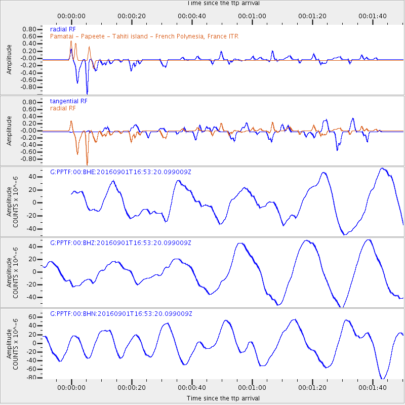
PPTF Pamatai - Papeete - Tahiti island - French Polynesia, France - Earthquake Result Viewer
*The percent match for this event was below the threshold and hence no stack was calculated.
| Earthquake location: |
Off E. Coast Of N. Island, N.Z. |
| Earthquake latitude/longitude: |
-37.4/179.8 |
| Earthquake time(UTC): |
2016/09/01 (245) 16:47:12 GMT |
| Earthquake Depth: |
10 km |
| Earthquake Magnitude: |
5.6 MB |
| Earthquake Catalog/Contributor: |
NEIC PDE/NEIC COMCAT |
|
| Network: |
G GEOSCOPE |
| Station: |
PPTF Pamatai - Papeete - Tahiti island - French Polynesia, France |
| Lat/Lon: |
17.59 S/149.57 W |
| Elevation: |
705 m |
|
| Distance: |
33.4 deg |
| Az: |
62.126 deg |
| Baz: |
227.563 deg |
| Ray Param: |
$rayparam |
*The percent match for this event was below the threshold and hence was not used in the summary stack. |
|
| Radial Match: |
92.288055 % |
| Radial Bump: |
400 |
| Transverse Match: |
30.103664 % |
| Transverse Bump: |
400 |
| SOD ConfigId: |
1634031 |
| Insert Time: |
2016-09-15 16:48:00.055 +0000 |
| GWidth: |
2.5 |
| Max Bumps: |
400 |
| Tol: |
0.001 |
|
Signal To Noise
| Channel | StoN | STA | LTA |
| G:PPTF:00:BHZ:20160901T16:53:20.099009Z | 1.540121 | 2.0467662E-5 | 1.3289645E-5 |
| G:PPTF:00:BHN:20160901T16:53:20.099009Z | 0.6870193 | 1.5365404E-5 | 2.2365317E-5 |
| G:PPTF:00:BHE:20160901T16:53:20.099009Z | 1.2495298 | 2.089719E-5 | 1.6724043E-5 |
| Arrivals |
| Ps | |
| PpPs | |
| PsPs/PpSs | |


