You are here: Home > Network List > US - United States National Seismic Network Stations List
> Station MNTX Cornudas Mountains, Texas, USA > Earthquake Result Viewer
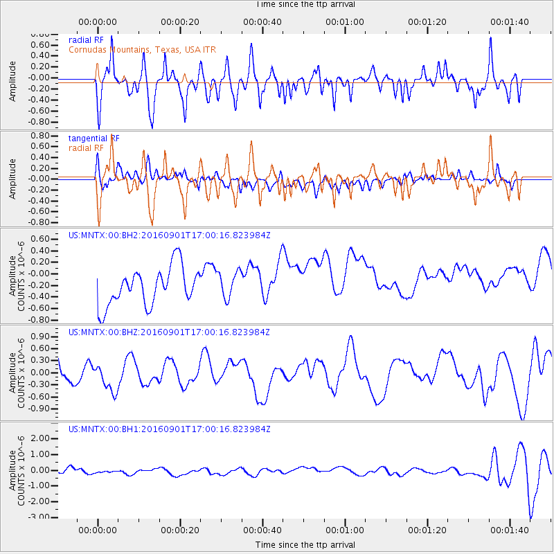
MNTX Cornudas Mountains, Texas, USA - Earthquake Result Viewer
*The percent match for this event was below the threshold and hence no stack was calculated.
| Earthquake location: |
Off E. Coast Of N. Island, N.Z. |
| Earthquake latitude/longitude: |
-37.4/179.8 |
| Earthquake time(UTC): |
2016/09/01 (245) 16:47:12 GMT |
| Earthquake Depth: |
10 km |
| Earthquake Magnitude: |
5.6 MB |
| Earthquake Catalog/Contributor: |
NEIC PDE/NEIC COMCAT |
|
| Network: |
US United States National Seismic Network |
| Station: |
MNTX Cornudas Mountains, Texas, USA |
| Lat/Lon: |
31.70 N/105.38 W |
| Elevation: |
404 m |
|
| Distance: |
98.0 deg |
| Az: |
56.172 deg |
| Baz: |
230.904 deg |
| Ray Param: |
$rayparam |
*The percent match for this event was below the threshold and hence was not used in the summary stack. |
|
| Radial Match: |
58.647152 % |
| Radial Bump: |
400 |
| Transverse Match: |
63.44353 % |
| Transverse Bump: |
400 |
| SOD ConfigId: |
1634031 |
| Insert Time: |
2016-09-15 16:49:05.504 +0000 |
| GWidth: |
2.5 |
| Max Bumps: |
400 |
| Tol: |
0.001 |
|
Signal To Noise
| Channel | StoN | STA | LTA |
| US:MNTX:00:BHZ:20160901T17:00:16.823984Z | 0.78927475 | 3.5204621E-7 | 4.460376E-7 |
| US:MNTX:00:BH1:20160901T17:00:16.823984Z | 1.275205 | 2.1825133E-7 | 1.7114999E-7 |
| US:MNTX:00:BH2:20160901T17:00:16.823984Z | 0.7130817 | 2.3249872E-7 | 3.2604777E-7 |
| Arrivals |
| Ps | |
| PpPs | |
| PsPs/PpSs | |


