You are here: Home > Network List > IU - Global Seismograph Network (GSN - IRIS/USGS) Stations List
> Station PMSA Palmer Station, Antarctica > Earthquake Result Viewer
PMSA Palmer Station, Antarctica - Earthquake Result Viewer
| Earthquake location: |
Off E. Coast Of N. Island, N.Z. |
| Earthquake latitude/longitude: |
-37.2/179.1 |
| Earthquake time(UTC): |
2016/09/01 (245) 16:48:02 GMT |
| Earthquake Depth: |
14 km |
| Earthquake Magnitude: |
5.6 MB |
| Earthquake Catalog/Contributor: |
NEIC PDE/NEIC COMCAT |
|
| Network: |
IU Global Seismograph Network (GSN - IRIS/USGS) |
| Station: |
PMSA Palmer Station, Antarctica |
| Lat/Lon: |
64.77 S/64.05 W |
| Elevation: |
40 m |
|
| Distance: |
67.0 deg |
| Az: |
155.456 deg |
| Baz: |
230.677 deg |
| Ray Param: |
0.057212934 |
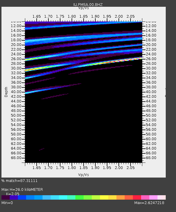
| Estimated Moho Depth: |
26.0 km |
| Estimated Crust Vp/Vs: |
2.05 |
| Assumed Crust Vp: |
6.183 km/s |
| Estimated Crust Vs: |
3.016 km/s |
| Estimated Crust Poisson's Ratio: |
0.34 |
|
| Radial Match: |
87.31111 % |
| Radial Bump: |
400 |
| Transverse Match: |
40.427902 % |
| Transverse Bump: |
400 |
| SOD ConfigId: |
1634031 |
| Insert Time: |
2016-09-15 16:50:41.389 +0000 |
| GWidth: |
2.5 |
| Max Bumps: |
400 |
| Tol: |
0.001 |
|
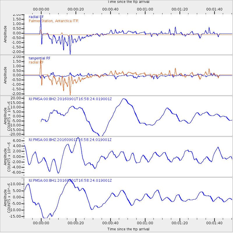
Signal To Noise
| Channel | StoN | STA | LTA |
| IU:PMSA:00:BHZ:20160901T16:58:24.019001Z | 0.8792511 | 2.8312227E-6 | 3.220039E-6 |
| IU:PMSA:00:BH1:20160901T16:58:24.019001Z | 1.8750159 | 1.581742E-5 | 8.435886E-6 |
| IU:PMSA:00:BH2:20160901T16:58:24.019001Z | 4.5934467 | 2.2797332E-5 | 4.963012E-6 |
| Arrivals |
| Ps | 4.6 SECOND |
| PpPs | 12 SECOND |
| PsPs/PpSs | 17 SECOND |


