You are here: Home > Network List > TA - USArray Transportable Network (new EarthScope stations) Stations List
> Station M21A Separation Peak, Rawlins, WY, USA > Earthquake Result Viewer
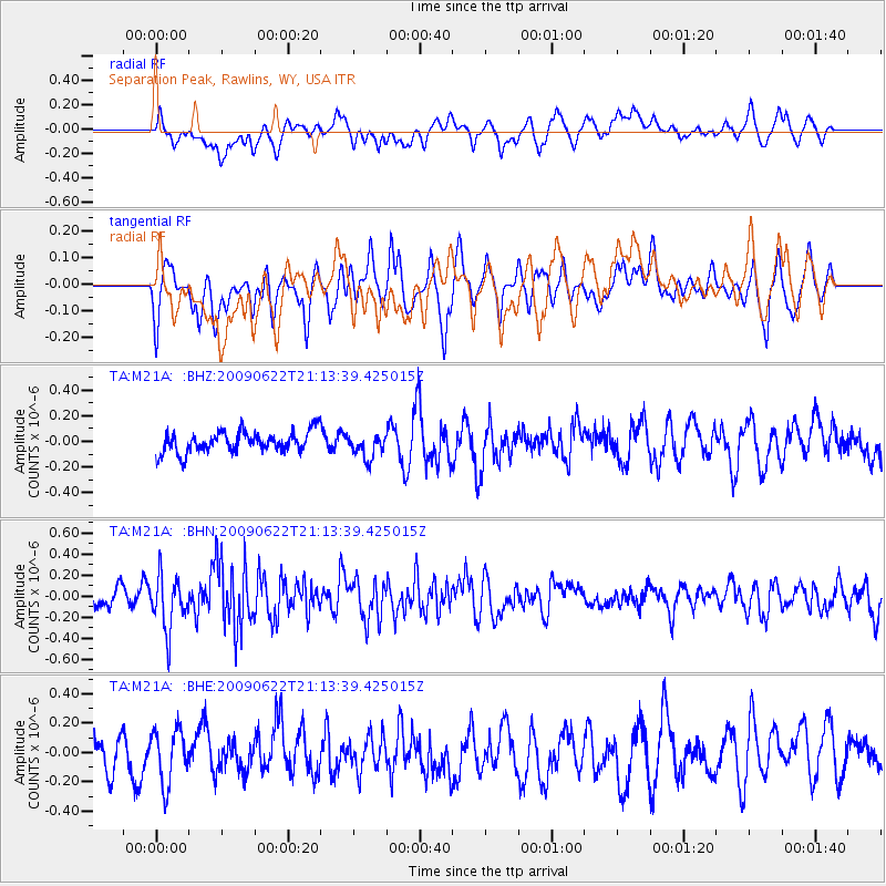
M21A Separation Peak, Rawlins, WY, USA - Earthquake Result Viewer
*The percent match for this event was below the threshold and hence no stack was calculated.
| Earthquake location: |
Andreanof Islands, Aleutian Is. |
| Earthquake latitude/longitude: |
51.3/-178.2 |
| Earthquake time(UTC): |
2009/06/22 (173) 21:05:33 GMT |
| Earthquake Depth: |
29 km |
| Earthquake Magnitude: |
5.5 MB, 5.0 MS, 5.4 MW, 5.4 MW |
| Earthquake Catalog/Contributor: |
WHDF/NEIC |
|
| Network: |
TA USArray Transportable Network (new EarthScope stations) |
| Station: |
M21A Separation Peak, Rawlins, WY, USA |
| Lat/Lon: |
41.61 N/107.36 W |
| Elevation: |
2275 m |
|
| Distance: |
48.0 deg |
| Az: |
72.486 deg |
| Baz: |
307.104 deg |
| Ray Param: |
$rayparam |
*The percent match for this event was below the threshold and hence was not used in the summary stack. |
|
| Radial Match: |
43.15399 % |
| Radial Bump: |
400 |
| Transverse Match: |
51.28068 % |
| Transverse Bump: |
400 |
| SOD ConfigId: |
2648 |
| Insert Time: |
2010-03-06 18:56:59.944 +0000 |
| GWidth: |
2.5 |
| Max Bumps: |
400 |
| Tol: |
0.001 |
|
Signal To Noise
| Channel | StoN | STA | LTA |
| TA:M21A: :BHN:20090622T21:13:39.425015Z | 2.6265686 | 2.5213205E-7 | 9.5992945E-8 |
| TA:M21A: :BHE:20090622T21:13:39.425015Z | 1.6499937 | 1.8099901E-7 | 1.096968E-7 |
| TA:M21A: :BHZ:20090622T21:13:39.425015Z | 1.139307 | 9.368923E-8 | 8.223352E-8 |
| Arrivals |
| Ps | |
| PpPs | |
| PsPs/PpSs | |


