You are here: Home > Network List > TA - USArray Transportable Network (new EarthScope stations) Stations List
> Station M21A Separation Peak, Rawlins, WY, USA > Earthquake Result Viewer
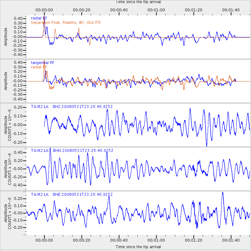
M21A Separation Peak, Rawlins, WY, USA - Earthquake Result Viewer
*The percent match for this event was below the threshold and hence no stack was calculated.
| Earthquake location: |
Easter Island Region |
| Earthquake latitude/longitude: |
-28.9/-112.3 |
| Earthquake time(UTC): |
2008/05/31 (152) 23:16:04 GMT |
| Earthquake Depth: |
10 km |
| Earthquake Magnitude: |
5.5 MS, 5.4 MB, 5.8 MW, 5.8 MW |
| Earthquake Catalog/Contributor: |
WHDF/NEIC |
|
| Network: |
TA USArray Transportable Network (new EarthScope stations) |
| Station: |
M21A Separation Peak, Rawlins, WY, USA |
| Lat/Lon: |
41.61 N/107.36 W |
| Elevation: |
2275 m |
|
| Distance: |
70.3 deg |
| Az: |
3.897 deg |
| Baz: |
184.556 deg |
| Ray Param: |
$rayparam |
*The percent match for this event was below the threshold and hence was not used in the summary stack. |
|
| Radial Match: |
59.033207 % |
| Radial Bump: |
400 |
| Transverse Match: |
66.24382 % |
| Transverse Bump: |
400 |
| SOD ConfigId: |
2504 |
| Insert Time: |
2010-03-06 18:57:18.803 +0000 |
| GWidth: |
2.5 |
| Max Bumps: |
400 |
| Tol: |
0.001 |
|
Signal To Noise
| Channel | StoN | STA | LTA |
| TA:M21A: :BHN:20080531T23:26:46.925Z | 4.454916 | 2.4937557E-7 | 5.5977615E-8 |
| TA:M21A: :BHE:20080531T23:26:46.925Z | 1.7626622 | 7.4136125E-8 | 4.2059177E-8 |
| TA:M21A: :BHZ:20080531T23:26:46.925Z | 1.5621198 | 9.084836E-8 | 5.81571E-8 |
| Arrivals |
| Ps | |
| PpPs | |
| PsPs/PpSs | |


