You are here: Home > Network List > UU - University of Utah Regional Network Stations List
> Station KNB Kanab, UT, USA > Earthquake Result Viewer
KNB Kanab, UT, USA - Earthquake Result Viewer
| Earthquake location: |
Off E. Coast Of N. Island, N.Z. |
| Earthquake latitude/longitude: |
-37.2/179.1 |
| Earthquake time(UTC): |
2016/09/01 (245) 17:36:00 GMT |
| Earthquake Depth: |
10 km |
| Earthquake Magnitude: |
5.6 MB |
| Earthquake Catalog/Contributor: |
NEIC PDE/NEIC COMCAT |
|
| Network: |
UU University of Utah Regional Network |
| Station: |
KNB Kanab, UT, USA |
| Lat/Lon: |
37.02 N/112.82 W |
| Elevation: |
1715 m |
|
| Distance: |
97.0 deg |
| Az: |
48.44 deg |
| Baz: |
228.304 deg |
| Ray Param: |
0.04033943 |
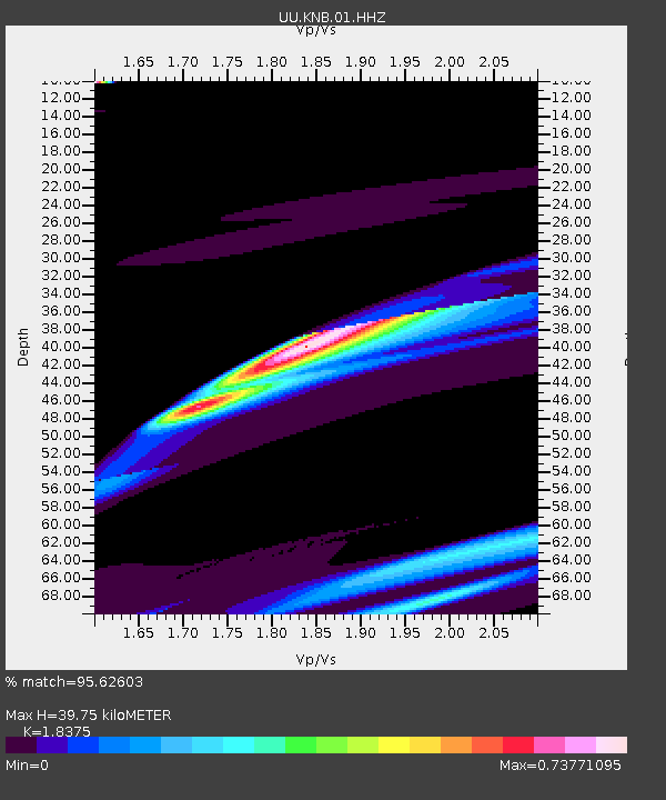
| Estimated Moho Depth: |
39.75 km |
| Estimated Crust Vp/Vs: |
1.84 |
| Assumed Crust Vp: |
6.194 km/s |
| Estimated Crust Vs: |
3.371 km/s |
| Estimated Crust Poisson's Ratio: |
0.29 |
|
| Radial Match: |
95.62603 % |
| Radial Bump: |
276 |
| Transverse Match: |
83.75969 % |
| Transverse Bump: |
400 |
| SOD ConfigId: |
1634031 |
| Insert Time: |
2016-09-15 17:38:04.216 +0000 |
| GWidth: |
2.5 |
| Max Bumps: |
400 |
| Tol: |
0.001 |
|

Signal To Noise
| Channel | StoN | STA | LTA |
| UU:KNB:01:HHZ:20160901T17:49:00.66498Z | 0.77690977 | 1.0777185E-7 | 1.3871862E-7 |
| UU:KNB:01:HHN:20160901T17:49:00.66498Z | 1.2514995 | 1.1127396E-7 | 8.891251E-8 |
| UU:KNB:01:HHE:20160901T17:49:00.66498Z | 1.276902 | 1.6721246E-7 | 1.3095169E-7 |
| Arrivals |
| Ps | 5.5 SECOND |
| PpPs | 18 SECOND |
| PsPs/PpSs | 23 SECOND |


