You are here: Home > Network List > TA - USArray Transportable Network (new EarthScope stations) Stations List
> Station B18K Kokolik River, AK, USA > Earthquake Result Viewer
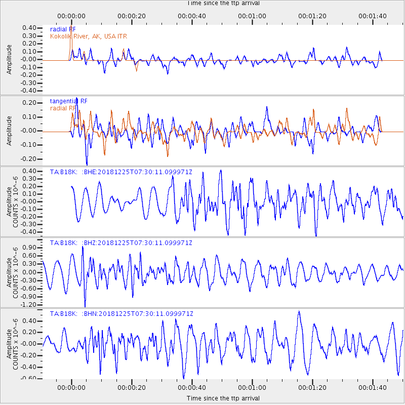
B18K Kokolik River, AK, USA - Earthquake Result Viewer
*The percent match for this event was below the threshold and hence no stack was calculated.
| Earthquake location: |
Northern Molucca Sea |
| Earthquake latitude/longitude: |
1.1/126.5 |
| Earthquake time(UTC): |
2018/12/25 (359) 07:18:19 GMT |
| Earthquake Depth: |
10 km |
| Earthquake Magnitude: |
5.2 Mww |
| Earthquake Catalog/Contributor: |
NEIC PDE/us |
|
| Network: |
TA USArray Transportable Network (new EarthScope stations) |
| Station: |
B18K Kokolik River, AK, USA |
| Lat/Lon: |
69.36 N/161.80 W |
| Elevation: |
222 m |
|
| Distance: |
82.5 deg |
| Az: |
19.846 deg |
| Baz: |
253.23 deg |
| Ray Param: |
$rayparam |
*The percent match for this event was below the threshold and hence was not used in the summary stack. |
|
| Radial Match: |
63.659077 % |
| Radial Bump: |
400 |
| Transverse Match: |
64.94912 % |
| Transverse Bump: |
400 |
| SOD ConfigId: |
13570011 |
| Insert Time: |
2019-05-02 04:44:21.284 +0000 |
| GWidth: |
2.5 |
| Max Bumps: |
400 |
| Tol: |
0.001 |
|
Signal To Noise
| Channel | StoN | STA | LTA |
| TA:B18K: :BHZ:20181225T07:30:11.099971Z | 2.0868452 | 5.58802E-7 | 2.6777357E-7 |
| TA:B18K: :BHN:20181225T07:30:11.099971Z | 0.8192167 | 8.179246E-8 | 9.984227E-8 |
| TA:B18K: :BHE:20181225T07:30:11.099971Z | 1.4175572 | 1.7750527E-7 | 1.2521912E-7 |
| Arrivals |
| Ps | |
| PpPs | |
| PsPs/PpSs | |


