You are here: Home > Network List > TA - USArray Transportable Network (new EarthScope stations) Stations List
> Station P17K Kvichak River, AK, USA > Earthquake Result Viewer
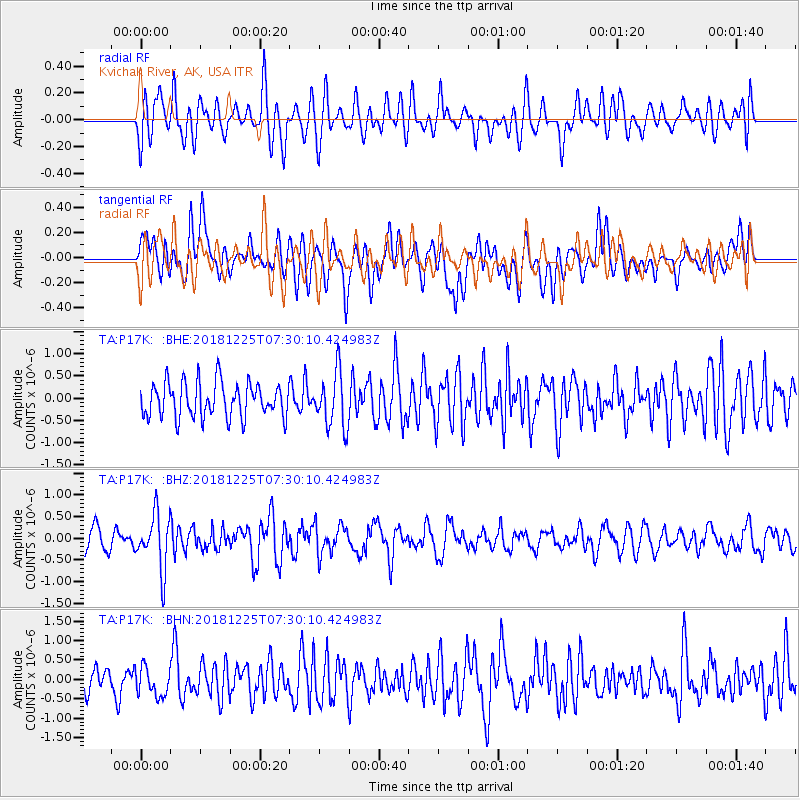
P17K Kvichak River, AK, USA - Earthquake Result Viewer
*The percent match for this event was below the threshold and hence no stack was calculated.
| Earthquake location: |
Northern Molucca Sea |
| Earthquake latitude/longitude: |
1.1/126.5 |
| Earthquake time(UTC): |
2018/12/25 (359) 07:18:19 GMT |
| Earthquake Depth: |
10 km |
| Earthquake Magnitude: |
5.2 Mww |
| Earthquake Catalog/Contributor: |
NEIC PDE/us |
|
| Network: |
TA USArray Transportable Network (new EarthScope stations) |
| Station: |
P17K Kvichak River, AK, USA |
| Lat/Lon: |
59.20 N/156.44 W |
| Elevation: |
91 m |
|
| Distance: |
82.4 deg |
| Az: |
30.402 deg |
| Baz: |
259.46 deg |
| Ray Param: |
$rayparam |
*The percent match for this event was below the threshold and hence was not used in the summary stack. |
|
| Radial Match: |
64.84276 % |
| Radial Bump: |
400 |
| Transverse Match: |
55.70208 % |
| Transverse Bump: |
400 |
| SOD ConfigId: |
13570011 |
| Insert Time: |
2019-05-02 04:45:12.215 +0000 |
| GWidth: |
2.5 |
| Max Bumps: |
400 |
| Tol: |
0.001 |
|
Signal To Noise
| Channel | StoN | STA | LTA |
| TA:P17K: :BHZ:20181225T07:30:10.424983Z | 2.3872285 | 6.367926E-7 | 2.6674977E-7 |
| TA:P17K: :BHN:20181225T07:30:10.424983Z | 0.78302985 | 3.7689128E-7 | 4.8132426E-7 |
| TA:P17K: :BHE:20181225T07:30:10.424983Z | 1.5858614 | 6.201938E-7 | 3.9107692E-7 |
| Arrivals |
| Ps | |
| PpPs | |
| PsPs/PpSs | |


