You are here: Home > Network List > TA - USArray Transportable Network (new EarthScope stations) Stations List
> Station F16A Kennard Place, Willow Creek, MT, USA > Earthquake Result Viewer
F16A Kennard Place, Willow Creek, MT, USA - Earthquake Result Viewer

| Earthquake location: |
North Of Severnaya Zemlya |
| Earthquake latitude/longitude: |
83.6/115.2 |
| Earthquake time(UTC): |
2008/08/13 (226) 08:35:02 GMT |
| Earthquake Depth: |
10 km |
| Earthquake Magnitude: |
5.5 MB, 4.7 MS, 5.4 MW, 5.4 MW |
| Earthquake Catalog/Contributor: |
WHDF/NEIC |
|
| Network: |
TA USArray Transportable Network (new EarthScope stations) |
| Station: |
F16A Kennard Place, Willow Creek, MT, USA |
| Lat/Lon: |
45.78 N/111.63 W |
| Elevation: |
1350 m |
|
| Distance: |
49.0 deg |
| Az: |
42.617 deg |
| Baz: |
353.807 deg |
| Ray Param: |
0.06901294 |
| Estimated Moho Depth: |
38.5 km |
| Estimated Crust Vp/Vs: |
1.70 |
| Assumed Crust Vp: |
6.35 km/s |
| Estimated Crust Vs: |
3.746 km/s |
| Estimated Crust Poisson's Ratio: |
0.23 |
|
| Radial Match: |
81.89803 % |
| Radial Bump: |
400 |
| Transverse Match: |
75.58823 % |
| Transverse Bump: |
400 |
| SOD ConfigId: |
2504 |
| Insert Time: |
2010-03-06 18:58:02.396 +0000 |
| GWidth: |
2.5 |
| Max Bumps: |
400 |
| Tol: |
0.001 |
|
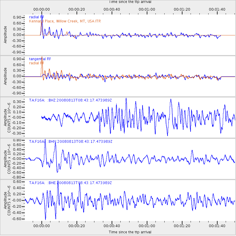
Signal To Noise
| Channel | StoN | STA | LTA |
| TA:F16A: :BHN:20080813T08:43:17.473989Z | 9.43279 | 3.1561416E-7 | 3.3459262E-8 |
| TA:F16A: :BHE:20080813T08:43:17.473989Z | 5.0537114 | 2.3675408E-7 | 4.6847564E-8 |
| TA:F16A: :BHZ:20080813T08:43:17.473989Z | 1.8312798 | 9.192605E-8 | 5.019771E-8 |
| Arrivals |
| Ps | 4.5 SECOND |
| PpPs | 15 SECOND |
| PsPs/PpSs | 20 SECOND |


