You are here: Home > Network List > TA - USArray Transportable Network (new EarthScope stations) Stations List
> Station F16A Kennard Place, Willow Creek, MT, USA > Earthquake Result Viewer
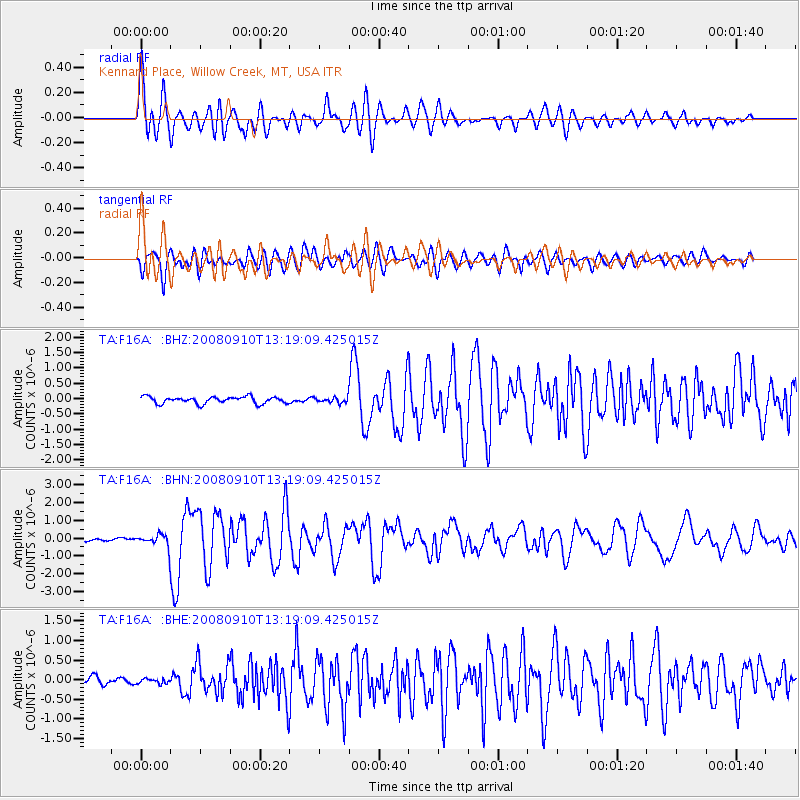
F16A Kennard Place, Willow Creek, MT, USA - Earthquake Result Viewer
| Earthquake location: |
Central Mid-Atlantic Ridge |
| Earthquake latitude/longitude: |
8.1/-38.7 |
| Earthquake time(UTC): |
2008/09/10 (254) 13:08:14 GMT |
| Earthquake Depth: |
10 km |
| Earthquake Magnitude: |
6.3 MB, 6.5 MS, 6.6 MW, 6.6 MW |
| Earthquake Catalog/Contributor: |
WHDF/NEIC |
|
| Network: |
TA USArray Transportable Network (new EarthScope stations) |
| Station: |
F16A Kennard Place, Willow Creek, MT, USA |
| Lat/Lon: |
45.78 N/111.63 W |
| Elevation: |
1350 m |
|
| Distance: |
72.3 deg |
| Az: |
315.414 deg |
| Baz: |
96.632 deg |
| Ray Param: |
0.053732276 |
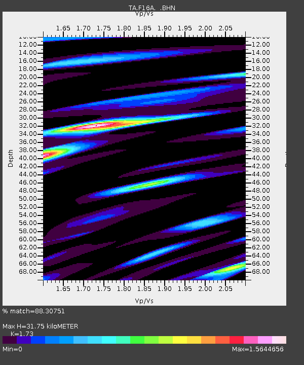
| Estimated Moho Depth: |
31.75 km |
| Estimated Crust Vp/Vs: |
1.73 |
| Assumed Crust Vp: |
6.35 km/s |
| Estimated Crust Vs: |
3.671 km/s |
| Estimated Crust Poisson's Ratio: |
0.25 |
|
| Radial Match: |
88.30751 % |
| Radial Bump: |
400 |
| Transverse Match: |
87.3049 % |
| Transverse Bump: |
400 |
| SOD ConfigId: |
2560 |
| Insert Time: |
2010-03-06 18:58:15.084 +0000 |
| GWidth: |
2.5 |
| Max Bumps: |
400 |
| Tol: |
0.001 |
|
Signal To Noise
| Channel | StoN | STA | LTA |
| TA:F16A: :BHN:20080910T13:19:09.425015Z | 5.5878716 | 3.4827642E-7 | 6.23272E-8 |
| TA:F16A: :BHE:20080910T13:19:09.425015Z | 0.7387197 | 6.042737E-8 | 8.180013E-8 |
| TA:F16A: :BHZ:20080910T13:19:09.425015Z | 0.7988402 | 8.801401E-8 | 1.1017724E-7 |
| Arrivals |
| Ps | 3.8 SECOND |
| PpPs | 13 SECOND |
| PsPs/PpSs | 17 SECOND |


