You are here: Home > Network List > CI - Caltech Regional Seismic Network Stations List
> Station MPM Manuel Prospect Mine, California, USA > Earthquake Result Viewer
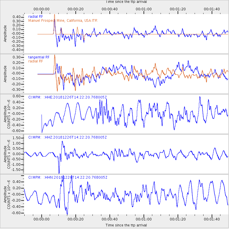
MPM Manuel Prospect Mine, California, USA - Earthquake Result Viewer
*The percent match for this event was below the threshold and hence no stack was calculated.
| Earthquake location: |
Tonga Islands |
| Earthquake latitude/longitude: |
-17.2/-173.6 |
| Earthquake time(UTC): |
2018/12/26 (360) 14:11:21 GMT |
| Earthquake Depth: |
163 km |
| Earthquake Magnitude: |
6.0 Mi |
| Earthquake Catalog/Contributor: |
NEIC PDE/pt |
|
| Network: |
CI Caltech Regional Seismic Network |
| Station: |
MPM Manuel Prospect Mine, California, USA |
| Lat/Lon: |
36.06 N/117.49 W |
| Elevation: |
185 m |
|
| Distance: |
74.9 deg |
| Az: |
44.157 deg |
| Baz: |
235.278 deg |
| Ray Param: |
$rayparam |
*The percent match for this event was below the threshold and hence was not used in the summary stack. |
|
| Radial Match: |
61.168102 % |
| Radial Bump: |
400 |
| Transverse Match: |
36.629906 % |
| Transverse Bump: |
400 |
| SOD ConfigId: |
13570011 |
| Insert Time: |
2019-05-02 04:48:36.006 +0000 |
| GWidth: |
2.5 |
| Max Bumps: |
400 |
| Tol: |
0.001 |
|
Signal To Noise
| Channel | StoN | STA | LTA |
| CI:MPM: :HHZ:20181226T14:22:20.768005Z | 1.0783309 | 1.3822124E-7 | 1.2818073E-7 |
| CI:MPM: :HHN:20181226T14:22:20.768005Z | 1.3821514 | 3.542244E-7 | 2.562848E-7 |
| CI:MPM: :HHE:20181226T14:22:20.768005Z | 1.0026685 | 2.50174E-7 | 2.4950816E-7 |
| Arrivals |
| Ps | |
| PpPs | |
| PsPs/PpSs | |


