You are here: Home > Network List > CN - Canadian National Seismograph Network Stations List
> Station INK INUVIK, NT > Earthquake Result Viewer
INK INUVIK, NT - Earthquake Result Viewer
*The percent match for this event was below the threshold and hence no stack was calculated.
| Earthquake location: |
Tonga Islands |
| Earthquake latitude/longitude: |
-17.2/-173.6 |
| Earthquake time(UTC): |
2018/12/26 (360) 14:11:21 GMT |
| Earthquake Depth: |
163 km |
| Earthquake Magnitude: |
6.0 Mi |
| Earthquake Catalog/Contributor: |
NEIC PDE/pt |
|
| Network: |
CN Canadian National Seismograph Network |
| Station: |
INK INUVIK, NT |
| Lat/Lon: |
68.31 N/133.53 W |
| Elevation: |
44 m |
|
| Distance: |
90.0 deg |
| Az: |
13.849 deg |
| Baz: |
217.988 deg |
| Ray Param: |
$rayparam |
*The percent match for this event was below the threshold and hence was not used in the summary stack. |
|
| Radial Match: |
60.127533 % |
| Radial Bump: |
400 |
| Transverse Match: |
52.060787 % |
| Transverse Bump: |
400 |
| SOD ConfigId: |
13570011 |
| Insert Time: |
2019-05-02 04:48:58.718 +0000 |
| GWidth: |
2.5 |
| Max Bumps: |
400 |
| Tol: |
0.001 |
|
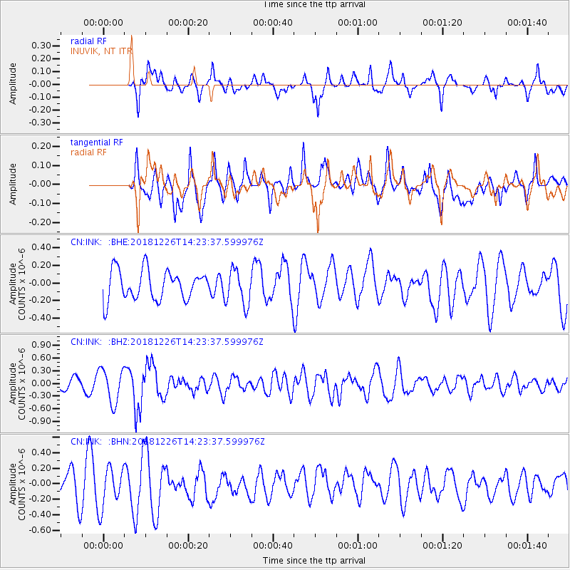
Signal To Noise
| Channel | StoN | STA | LTA |
| CN:INK: :BHZ:20181226T14:23:37.599976Z | 2.7348719 | 4.0815786E-7 | 1.4924204E-7 |
| CN:INK: :BHN:20181226T14:23:37.599976Z | 1.6603367 | 2.5665767E-7 | 1.5458168E-7 |
| CN:INK: :BHE:20181226T14:23:37.599976Z | 0.49121425 | 9.0955844E-8 | 1.8516533E-7 |
| Arrivals |
| Ps | |
| PpPs | |
| PsPs/PpSs | |


