You are here: Home > Network List > IW - Intermountain West Stations List
> Station DLMT Dillon, Montana, USA > Earthquake Result Viewer
DLMT Dillon, Montana, USA - Earthquake Result Viewer
*The percent match for this event was below the threshold and hence no stack was calculated.
| Earthquake location: |
Tonga Islands |
| Earthquake latitude/longitude: |
-17.2/-173.6 |
| Earthquake time(UTC): |
2018/12/26 (360) 14:11:21 GMT |
| Earthquake Depth: |
163 km |
| Earthquake Magnitude: |
6.0 Mi |
| Earthquake Catalog/Contributor: |
NEIC PDE/pt |
|
| Network: |
IW Intermountain West |
| Station: |
DLMT Dillon, Montana, USA |
| Lat/Lon: |
45.36 N/112.60 W |
| Elevation: |
1569 m |
|
| Distance: |
83.2 deg |
| Az: |
38.392 deg |
| Baz: |
237.37 deg |
| Ray Param: |
$rayparam |
*The percent match for this event was below the threshold and hence was not used in the summary stack. |
|
| Radial Match: |
62.823917 % |
| Radial Bump: |
400 |
| Transverse Match: |
44.93332 % |
| Transverse Bump: |
400 |
| SOD ConfigId: |
13570011 |
| Insert Time: |
2019-05-02 04:49:47.296 +0000 |
| GWidth: |
2.5 |
| Max Bumps: |
400 |
| Tol: |
0.001 |
|
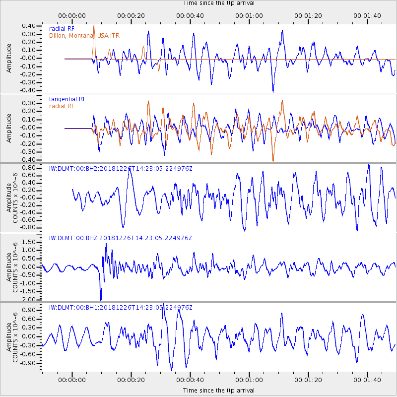
Signal To Noise
| Channel | StoN | STA | LTA |
| IW:DLMT:00:BHZ:20181226T14:23:05.224976Z | 0.6204146 | 1.0007594E-7 | 1.6130492E-7 |
| IW:DLMT:00:BH1:20181226T14:23:05.224976Z | 0.8312035 | 2.3581985E-7 | 2.837089E-7 |
| IW:DLMT:00:BH2:20181226T14:23:05.224976Z | 1.221808 | 2.5388525E-7 | 2.0779474E-7 |
| Arrivals |
| Ps | |
| PpPs | |
| PsPs/PpSs | |


