You are here: Home > Network List > TA - USArray Transportable Network (new EarthScope stations) Stations List
> Station F16A Kennard Place, Willow Creek, MT, USA > Earthquake Result Viewer
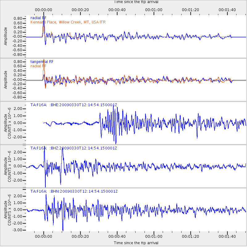
F16A Kennard Place, Willow Creek, MT, USA - Earthquake Result Viewer

| Earthquake location: |
Andreanof Islands, Aleutian Is. |
| Earthquake latitude/longitude: |
51.5/-178.3 |
| Earthquake time(UTC): |
2009/03/30 (089) 12:07:28 GMT |
| Earthquake Depth: |
31 km |
| Earthquake Magnitude: |
6.0 MB, 5.5 MS, 5.7 MW, 5.7 MW |
| Earthquake Catalog/Contributor: |
WHDF/NEIC |
|
| Network: |
TA USArray Transportable Network (new EarthScope stations) |
| Station: |
F16A Kennard Place, Willow Creek, MT, USA |
| Lat/Lon: |
45.78 N/111.63 W |
| Elevation: |
1350 m |
|
| Distance: |
43.0 deg |
| Az: |
70.344 deg |
| Baz: |
302.799 deg |
| Ray Param: |
0.072766766 |
| Estimated Moho Depth: |
61.75 km |
| Estimated Crust Vp/Vs: |
2.10 |
| Assumed Crust Vp: |
6.35 km/s |
| Estimated Crust Vs: |
3.031 km/s |
| Estimated Crust Poisson's Ratio: |
0.35 |
|
| Radial Match: |
82.22952 % |
| Radial Bump: |
400 |
| Transverse Match: |
76.12283 % |
| Transverse Bump: |
400 |
| SOD ConfigId: |
2658 |
| Insert Time: |
2010-03-06 18:58:50.578 +0000 |
| GWidth: |
2.5 |
| Max Bumps: |
400 |
| Tol: |
0.001 |
|
Signal To Noise
| Channel | StoN | STA | LTA |
| TA:F16A: :BHZ:20090330T12:14:54.150001Z | 6.6929455 | 9.904238E-7 | 1.4798027E-7 |
| TA:F16A: :BHN:20090330T12:14:54.150001Z | 7.654305 | 8.037544E-7 | 1.0500684E-7 |
| TA:F16A: :BHE:20090330T12:14:54.150001Z | 6.0125303 | 7.4903505E-7 | 1.24579E-7 |
| Arrivals |
| Ps | 11 SECOND |
| PpPs | 28 SECOND |
| PsPs/PpSs | 40 SECOND |


