You are here: Home > Network List > TA - USArray Transportable Network (new EarthScope stations) Stations List
> Station F16A Kennard Place, Willow Creek, MT, USA > Earthquake Result Viewer
F16A Kennard Place, Willow Creek, MT, USA - Earthquake Result Viewer
| Earthquake location: |
Kuril Islands |
| Earthquake latitude/longitude: |
46.0/151.4 |
| Earthquake time(UTC): |
2009/04/18 (108) 19:17:58 GMT |
| Earthquake Depth: |
35 km |
| Earthquake Magnitude: |
6.3 MB, 6.3 MS, 6.6 MW, 6.4 MW |
| Earthquake Catalog/Contributor: |
WHDF/NEIC |
|
| Network: |
TA USArray Transportable Network (new EarthScope stations) |
| Station: |
F16A Kennard Place, Willow Creek, MT, USA |
| Lat/Lon: |
45.78 N/111.63 W |
| Elevation: |
1350 m |
|
| Distance: |
63.0 deg |
| Az: |
51.198 deg |
| Baz: |
309.095 deg |
| Ray Param: |
0.059775513 |
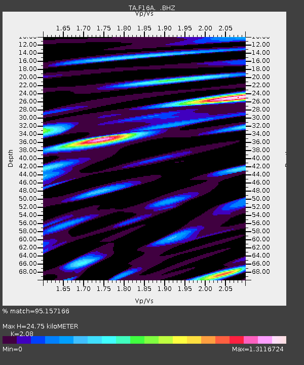
| Estimated Moho Depth: |
24.75 km |
| Estimated Crust Vp/Vs: |
2.08 |
| Assumed Crust Vp: |
6.35 km/s |
| Estimated Crust Vs: |
3.053 km/s |
| Estimated Crust Poisson's Ratio: |
0.35 |
|
| Radial Match: |
95.157166 % |
| Radial Bump: |
400 |
| Transverse Match: |
87.06331 % |
| Transverse Bump: |
400 |
| SOD ConfigId: |
2760 |
| Insert Time: |
2010-03-06 18:58:57.507 +0000 |
| GWidth: |
2.5 |
| Max Bumps: |
400 |
| Tol: |
0.001 |
|

Signal To Noise
| Channel | StoN | STA | LTA |
| TA:F16A: :BHZ:20090418T19:27:51.750007Z | 27.734545 | 2.2914815E-6 | 8.262192E-8 |
| TA:F16A: :BHN:20090418T19:27:51.750007Z | 8.47227 | 9.871784E-7 | 1.16518756E-7 |
| TA:F16A: :BHE:20090418T19:27:51.750007Z | 7.6142607 | 8.7816966E-7 | 1.15332234E-7 |
| Arrivals |
| Ps | 4.4 SECOND |
| PpPs | 12 SECOND |
| PsPs/PpSs | 16 SECOND |


