You are here: Home > Network List > TS - TERRAscope (Southern California Seismic Network) Stations List
> Station CALB Calabasas, California, USA > Earthquake Result Viewer
CALB Calabasas, California, USA - Earthquake Result Viewer
| Earthquake location: |
Vanuatu Islands |
| Earthquake latitude/longitude: |
-19.5/169.2 |
| Earthquake time(UTC): |
1995/06/29 (180) 12:24:03 GMT |
| Earthquake Depth: |
144 km |
| Earthquake Magnitude: |
6.2 MB, 6.7 UNKNOWN, 6.6 MW |
| Earthquake Catalog/Contributor: |
WHDF/NEIC |
|
| Network: |
TS TERRAscope (Southern California Seismic Network) |
| Station: |
CALB Calabasas, California, USA |
| Lat/Lon: |
34.14 N/118.63 W |
| Elevation: |
0.0 m |
|
| Distance: |
86.8 deg |
| Az: |
52.24 deg |
| Baz: |
244.08 deg |
| Ray Param: |
0.04343272 |
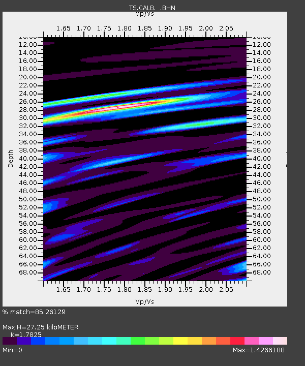
| Estimated Moho Depth: |
27.25 km |
| Estimated Crust Vp/Vs: |
1.78 |
| Assumed Crust Vp: |
6.1 km/s |
| Estimated Crust Vs: |
3.422 km/s |
| Estimated Crust Poisson's Ratio: |
0.27 |
|
| Radial Match: |
85.26129 % |
| Radial Bump: |
400 |
| Transverse Match: |
82.703964 % |
| Transverse Bump: |
400 |
| SOD ConfigId: |
6273 |
| Insert Time: |
2010-02-26 14:02:50.504 +0000 |
| GWidth: |
2.5 |
| Max Bumps: |
400 |
| Tol: |
0.001 |
|

Signal To Noise
| Channel | StoN | STA | LTA |
| TS:CALB: :BHN:19950629T12:36:00.980994Z | 2.0386698 | 4.2123713E-7 | 2.0662351E-7 |
| TS:CALB: :BHE:19950629T12:36:00.980994Z | 4.4033294 | 1.1893222E-6 | 2.7009614E-7 |
| TS:CALB: :BHZ:19950629T12:36:00.980994Z | 22.72475 | 4.4125873E-6 | 1.941754E-7 |
| Arrivals |
| Ps | 3.6 SECOND |
| PpPs | 12 SECOND |
| PsPs/PpSs | 16 SECOND |


