You are here: Home > Network List > TA - USArray Transportable Network (new EarthScope stations) Stations List
> Station 121A Cookes Peak, Deming, NM, USA > Earthquake Result Viewer
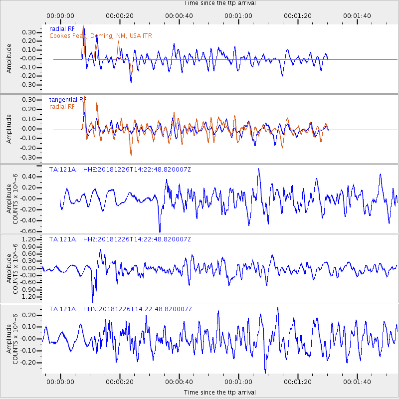
121A Cookes Peak, Deming, NM, USA - Earthquake Result Viewer
*The percent match for this event was below the threshold and hence no stack was calculated.
| Earthquake location: |
Tonga Islands |
| Earthquake latitude/longitude: |
-17.2/-173.6 |
| Earthquake time(UTC): |
2018/12/26 (360) 14:11:21 GMT |
| Earthquake Depth: |
163 km |
| Earthquake Magnitude: |
6.0 Mi |
| Earthquake Catalog/Contributor: |
NEIC PDE/pt |
|
| Network: |
TA USArray Transportable Network (new EarthScope stations) |
| Station: |
121A Cookes Peak, Deming, NM, USA |
| Lat/Lon: |
32.53 N/107.79 W |
| Elevation: |
1652 m |
|
| Distance: |
80.0 deg |
| Az: |
51.49 deg |
| Baz: |
242.329 deg |
| Ray Param: |
$rayparam |
*The percent match for this event was below the threshold and hence was not used in the summary stack. |
|
| Radial Match: |
59.39762 % |
| Radial Bump: |
400 |
| Transverse Match: |
55.718113 % |
| Transverse Bump: |
400 |
| SOD ConfigId: |
13570011 |
| Insert Time: |
2019-05-02 04:52:07.102 +0000 |
| GWidth: |
2.5 |
| Max Bumps: |
400 |
| Tol: |
0.001 |
|
Signal To Noise
| Channel | StoN | STA | LTA |
| TA:121A: :HHZ:20181226T14:22:48.820007Z | 1.08076 | 1.1447023E-7 | 1.0591643E-7 |
| TA:121A: :HHN:20181226T14:22:48.820007Z | 0.89213294 | 5.1119116E-8 | 5.7299886E-8 |
| TA:121A: :HHE:20181226T14:22:48.820007Z | 0.56004703 | 6.148813E-8 | 1.0979101E-7 |
| Arrivals |
| Ps | |
| PpPs | |
| PsPs/PpSs | |


