You are here: Home > Network List > TA - USArray Transportable Network (new EarthScope stations) Stations List
> Station H16K Elim, AK, USA > Earthquake Result Viewer
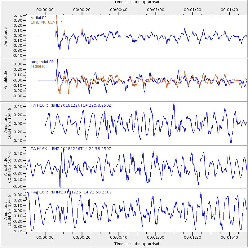
H16K Elim, AK, USA - Earthquake Result Viewer
*The percent match for this event was below the threshold and hence no stack was calculated.
| Earthquake location: |
Tonga Islands |
| Earthquake latitude/longitude: |
-17.2/-173.6 |
| Earthquake time(UTC): |
2018/12/26 (360) 14:11:21 GMT |
| Earthquake Depth: |
163 km |
| Earthquake Magnitude: |
6.0 Mi |
| Earthquake Catalog/Contributor: |
NEIC PDE/pt |
|
| Network: |
TA USArray Transportable Network (new EarthScope stations) |
| Station: |
H16K Elim, AK, USA |
| Lat/Lon: |
64.64 N/162.24 W |
| Elevation: |
216 m |
|
| Distance: |
82.0 deg |
| Az: |
4.915 deg |
| Baz: |
190.964 deg |
| Ray Param: |
$rayparam |
*The percent match for this event was below the threshold and hence was not used in the summary stack. |
|
| Radial Match: |
55.26019 % |
| Radial Bump: |
400 |
| Transverse Match: |
50.306618 % |
| Transverse Bump: |
400 |
| SOD ConfigId: |
13570011 |
| Insert Time: |
2019-05-02 04:52:36.952 +0000 |
| GWidth: |
2.5 |
| Max Bumps: |
400 |
| Tol: |
0.001 |
|
Signal To Noise
| Channel | StoN | STA | LTA |
| TA:H16K: :BHZ:20181226T14:22:58.250Z | 0.9334251 | 1.3801599E-7 | 1.4785974E-7 |
| TA:H16K: :BHN:20181226T14:22:58.250Z | 0.587638 | 1.1914561E-7 | 2.0275341E-7 |
| TA:H16K: :BHE:20181226T14:22:58.250Z | 1.5051475 | 2.0684224E-7 | 1.3742324E-7 |
| Arrivals |
| Ps | |
| PpPs | |
| PsPs/PpSs | |


