You are here: Home > Network List > TA - USArray Transportable Network (new EarthScope stations) Stations List
> Station M11K Mekoryuk, AK, USA > Earthquake Result Viewer
M11K Mekoryuk, AK, USA - Earthquake Result Viewer
*The percent match for this event was below the threshold and hence no stack was calculated.
| Earthquake location: |
Tonga Islands |
| Earthquake latitude/longitude: |
-17.2/-173.6 |
| Earthquake time(UTC): |
2018/12/26 (360) 14:11:21 GMT |
| Earthquake Depth: |
163 km |
| Earthquake Magnitude: |
6.0 Mi |
| Earthquake Catalog/Contributor: |
NEIC PDE/pt |
|
| Network: |
TA USArray Transportable Network (new EarthScope stations) |
| Station: |
M11K Mekoryuk, AK, USA |
| Lat/Lon: |
60.38 N/166.20 W |
| Elevation: |
3.0 m |
|
| Distance: |
77.5 deg |
| Az: |
3.757 deg |
| Baz: |
187.245 deg |
| Ray Param: |
$rayparam |
*The percent match for this event was below the threshold and hence was not used in the summary stack. |
|
| Radial Match: |
51.73912 % |
| Radial Bump: |
400 |
| Transverse Match: |
61.395645 % |
| Transverse Bump: |
400 |
| SOD ConfigId: |
13570011 |
| Insert Time: |
2019-05-02 04:52:54.910 +0000 |
| GWidth: |
2.5 |
| Max Bumps: |
400 |
| Tol: |
0.001 |
|
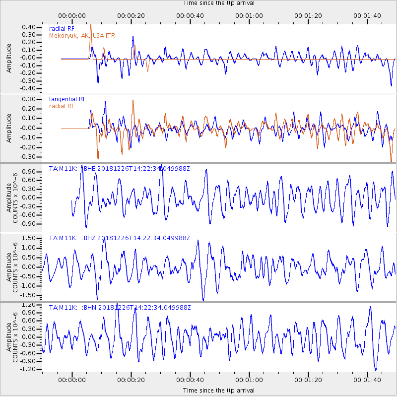
Signal To Noise
| Channel | StoN | STA | LTA |
| TA:M11K: :BHZ:20181226T14:22:34.049988Z | 1.5848376 | 5.769343E-7 | 3.6403372E-7 |
| TA:M11K: :BHN:20181226T14:22:34.049988Z | 0.63736314 | 3.114596E-7 | 4.88669E-7 |
| TA:M11K: :BHE:20181226T14:22:34.049988Z | 0.6144145 | 2.81459E-7 | 4.58093E-7 |
| Arrivals |
| Ps | |
| PpPs | |
| PsPs/PpSs | |


