You are here: Home > Network List > TA - USArray Transportable Network (new EarthScope stations) Stations List
> Station S22A 4UR Ranch, Creede, CO, USA > Earthquake Result Viewer
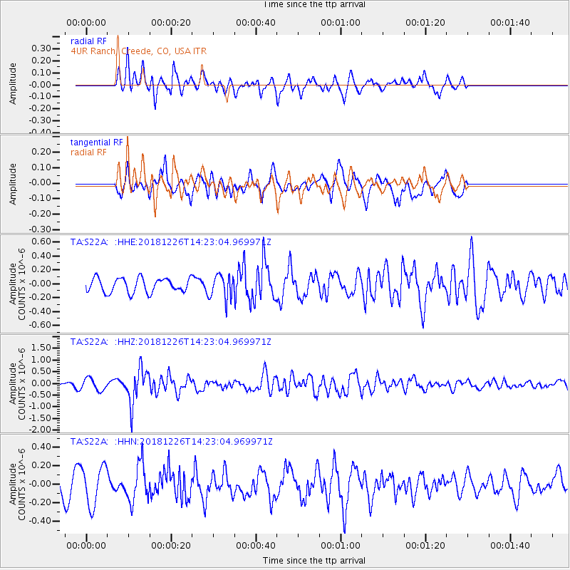
S22A 4UR Ranch, Creede, CO, USA - Earthquake Result Viewer
*The percent match for this event was below the threshold and hence no stack was calculated.
| Earthquake location: |
Tonga Islands |
| Earthquake latitude/longitude: |
-17.2/-173.6 |
| Earthquake time(UTC): |
2018/12/26 (360) 14:11:21 GMT |
| Earthquake Depth: |
163 km |
| Earthquake Magnitude: |
6.0 Mi |
| Earthquake Catalog/Contributor: |
NEIC PDE/pt |
|
| Network: |
TA USArray Transportable Network (new EarthScope stations) |
| Station: |
S22A 4UR Ranch, Creede, CO, USA |
| Lat/Lon: |
37.75 N/106.83 W |
| Elevation: |
2626 m |
|
| Distance: |
83.1 deg |
| Az: |
47.204 deg |
| Baz: |
242.246 deg |
| Ray Param: |
$rayparam |
*The percent match for this event was below the threshold and hence was not used in the summary stack. |
|
| Radial Match: |
55.8028 % |
| Radial Bump: |
400 |
| Transverse Match: |
56.428223 % |
| Transverse Bump: |
370 |
| SOD ConfigId: |
13570011 |
| Insert Time: |
2019-05-02 04:53:16.601 +0000 |
| GWidth: |
2.5 |
| Max Bumps: |
400 |
| Tol: |
0.001 |
|
Signal To Noise
| Channel | StoN | STA | LTA |
| TA:S22A: :HHZ:20181226T14:23:04.969971Z | 1.8021958 | 2.5567692E-7 | 1.4186968E-7 |
| TA:S22A: :HHN:20181226T14:23:04.969971Z | 2.09253 | 2.1537547E-7 | 1.0292587E-7 |
| TA:S22A: :HHE:20181226T14:23:04.969971Z | 0.9034593 | 1.0093502E-7 | 1.1172061E-7 |
| Arrivals |
| Ps | |
| PpPs | |
| PsPs/PpSs | |


